

The lagoon enigma
There is a recurrent character in the legend of Paititi as well as in many chroniclers: the presence of a lagoon around the mountain on which Paititi is located. From this lagoon there were, according to certain versions, a path made of black stone slabs that allowed access to the heart of the city.
However, it must be noted that, unlike all the other elements mentioned in the legend, there is no lagoon strictly speaking on the site. How to explain that? First, it must be understood, and the case is not isolated, that on this point a flaw in translation has from the beginning induced the Spaniards in error:
Indeed, the Indians speaking to them of Paititi, who lived by the rivers, had in their dialect a thousand and one words to designate the rivers. The word “cocha” in Quechua , wtich is at the origine of the misunderstood, is the equivalent of the term “para” in the Tupi Caribbean language, which means “large water” in general. In the Incas themselves “cocha” was a word meaning a lot of things, depending on the context a large “cocha” could mean the sea, but just as much a large lagoon, a lake, flooded land, or even a river…
An illustration of this confusion, a lagoon originally designates an area of brackish water separated from the sea by a sandy cordon, but in the Amazonia we find the term everywhere:
The term “Para”, the concept of “great water” of the Tupi-Caribes was therefore in most cases translated to missionaries or conquistadores by Quechua interpreters, who themselves already designated this concept by another word (cocha) with a meaning probably slightly different, all without the slightest idea, since the translators themselves did not know Paititi, from what they were really alluding to. The chroniclers could not grasp the multiplicity of meanings of this word, and if in this precise context it meant lagoon or something else. Let us go back to the original concept of “big water”, bearing in mind that the famous lagoon can therefore designate any kind of expanse of water.
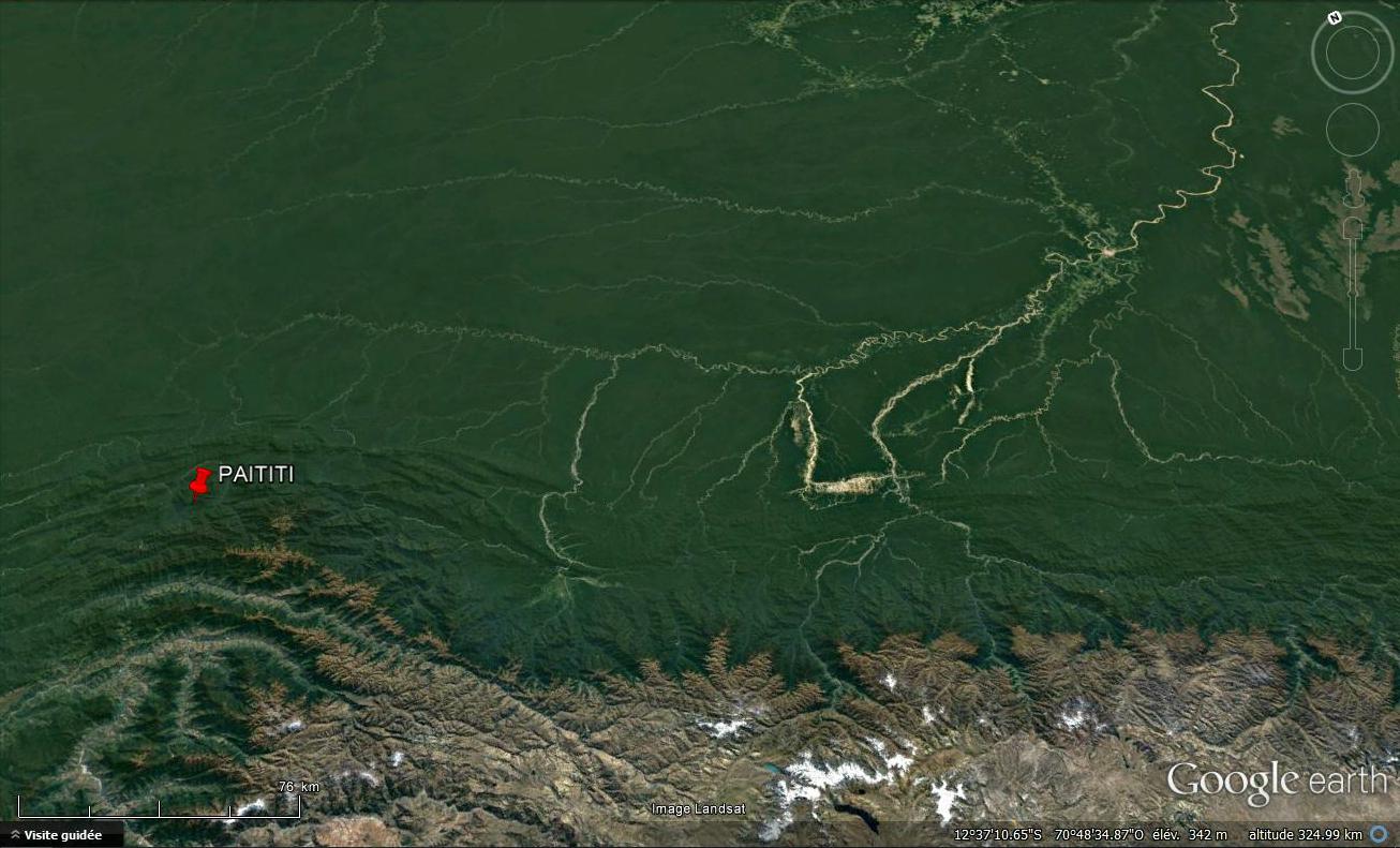
Rivers run along almost every side of the rocky Paititi massif, which from many angles gives the impression of a mountain surrounded by a true moat, but we are still quite far from a large lagoon with a “Island-mountain” in the middle.
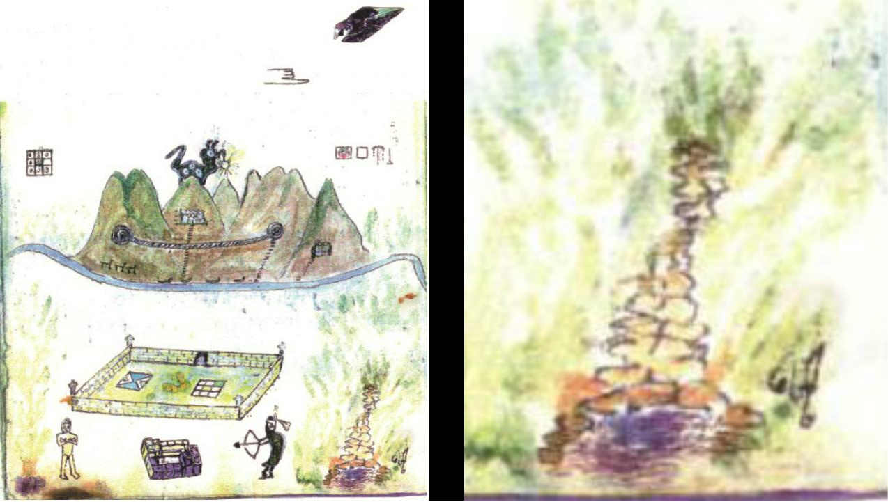
Blas Valera did not represent a lagoon, but he did draw boats that skirted the mountain, and sail to the unprotected part of the rocky bar, seemingly the only way to reach the plateau. In reality, this is also the case: the walls of the plateau are everywhere extremely abrupt, except on this rear part, after the rock bar. The principal access to the city would thus have been made by this side. And in facts, I found this main acces.
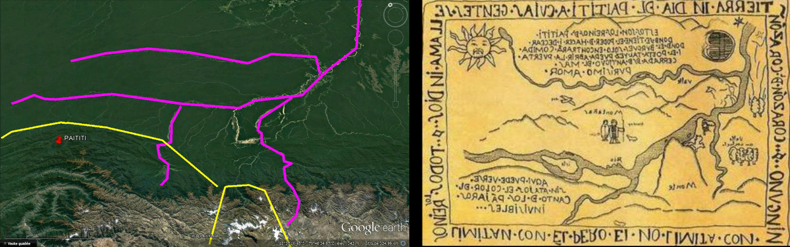
In 500 years, the living water of the Andes and the vegetation have modified the banks of the river and it is difficult to discern their previous contours. But by studying the topography in detail, two zones appeared to me to be reservoirs of water almost natural, which could in any case be created by constructing a dam, which was quite within the reach of the Incas, witch so well mastered water. The one on the left, requiring only a barrage of very small width, is at the place where the boats are drawn, and from which, according to my observations, follows an important road which ascends to the city, could have been the famous lagoon. It seems quite small here but its not at all.
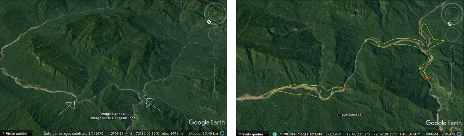
Preferring to stay very careful with the data indicated by the software, I only traced the body of water that the indicated altitudes should naturally create. In reality, the river must make its way through a narrow gorge at the point marked with a red dot. If a dam is considered taking advantage of the topography of the site, using as a solid base rock blocks precipitated in the gorge from the two adjacent mountains, one can easily reach a reservoir of water 5 kilometers long and about 2 kilometers wide , which would extend before the second half of the great rock bar, and which would be fed by the river bypassing the mountain.
It remained at this stage speculation, but an interesting possibility. It is by obtaining finally a version of the drawing of Blas Valera of better quality that I noted a detail that confers a completely different dimension to this hypothesis:
Pictures from the manuscrit Exsul Immeritus Blas Valera Populo Suo, Collection Miccinelli
If it does not represent a throat hampered by rocks, a dam holding water … Again, I was surprised by the link beetween my suppositions and the evidence I find then, it is as if Blas Valera guided my thought and then provided me the solutions … This dam is well drawn on the back of the mountain, and was even placed on the side of the river where I had envisaged it.
Given the nature of the terrain, it would have created a reservoir of water of great size, in any case large enough to deserve the name of “big water”. It can be said that its artificial character would have profoundly marked the Indians of the forest, who would not fail to mention this extraordinary artificial reservoir of water, a little in the way we describe the cities that we discover by their most Impressive monuments.
We can also add that the chiriguanaes who mainly informed the Spaniards about Paititi (see below), arrived at the site, the objective of their raids, from this side from the source of the Manu, and should therefore see in the foreground this large lagoon, then behind the imposing mountain, surrounded on each side by the rivers. They did not see the other side, and supposed that the mountain was planted in the middle of a kind of immense lake.
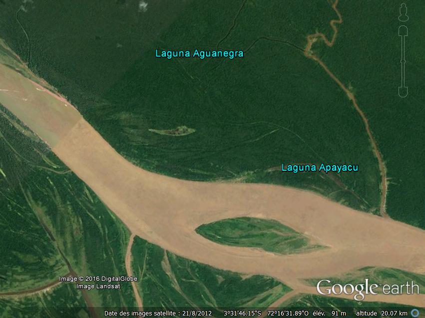
Very interesting observation, I just realized that a legend in Google Earth gives the river that surrounds Paititi the name of a lagoon, and not just any one : “Laguna Origen del Ma”, I think with A small fault “Lagoon origin of the sea” … It says a lot about the fact that this river loop was well regarded as a lagoon, and on the other hand its importance : the origin of the sea , nothing but that … And for good reason: Paititi is in the precise zone of the birth of all the tributaries of the Amazon. We know the importance of this giant river on the South American continent, and this name suggests that for the amazonian Indians it originated in Paititi and then filled the Atlantic ocean.
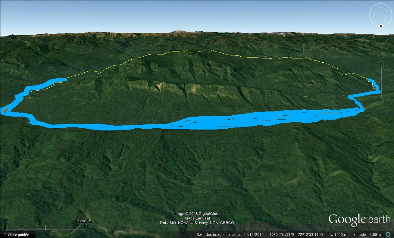
I had to take a little distance and height so that the whole appears under Google Earth, but from the summit of the last forest ridge (in the top of the foreground here), the view of the lagoon and the mountain behind it had to be well more striking. The dimensions are colossal.
Add to this the fact that the few chiriguanaes whitch during their raids arrived until then had to describe this landscape orally to the members of their tribe who did not see the site, that the description was passed on from generation to generation for hundreds of years (as we will see) before reaching the Spaniards, then the difficulties of translation explained above, and you will get the only mountain of the whole continent to be in the center of a lake.
Thus, Gonzalo Solis de Holguin, the one who followed the chiriguanaes from Santa-cruz in Bolivia to the land of the “Toros”, which appears to be north of the plains of Mojos (south-est of Paititi) collects information on a great lord reigning further north, called Yaya, leading a people dressed “like us” called “raqui” and armed with fronds “like the Indians of Peru”. He also learns that where the Yaya lives, a large lagoon surrounds a high mountain.
Confirmation by the maps
The mystery of the lagoon solved, let us see to what extent this geographical feature, so often quoted in the descriptions, could have directed us from the outset on the location of Paititi.
I am passionate about old maps. If there is one thing that one can immediately realize by studying them and comparing them to Google Earth, it is that they are absolutely all false, and in general quite widely, that is what makes their charm. It is understandable that, at the time when it were carried out, the precise datas were badly missing, so their authors tried to compile as much as possible informations derived from direct observations in the near field, more or less clear reports, and for areas which have remained untouched by any exploration, of oral indications of premises.
It is this last point that interests me. In spite of the vagueness of this information probably collected orally with great difficulty from the Indians of the forest not accustomed to cartographic rigor, one can still discern some useful clues. We know that they knew Paititi, and described it as a mountain surrounded by water. If a cartographer questioned them on his site, it was thus that he had to represent it then, placing it in a sector indicated by them taking as references the great mountains or the important rivers.
Now, this is what I noticed on several maps:
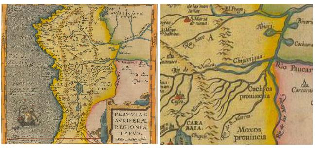
We can note the representation of a lake with an island in the middle, called “Tibiari”. The course of the rivers is completely false, since the area was very little seen not at all explored by the Spaniards in 1597. However we can still recognize the high basin of the Madre de Dios / Madeira below, and the top Ucayali basin above, whose most southern arm is the Urubamba. The two high basins are actually not connected as on the map, but we might think that at the time the rio Manu seemed to make them communicate. Finally, the location of Cusco and Titicaca make the nearby mountain range of Pantiacolla identifiable.
No lake in the area between these four landmarks exists on the satellite views, which suggests that the indication was oral. The representation of an island makes one think clearly of the idea of Paititi that the Indians of the forest were made. And indeed, Paititi is in this area.
I carried out long research on the term “Tibiari”, finally finding in an old work that it corresponded to the name of a tribe on which I could not gather any information. In Guarani, “Ari” would mean “above” or “on”, but I did not find what “Tibi” could refer to etymologically. I am not persuaded that the origin of the term is Guarani…
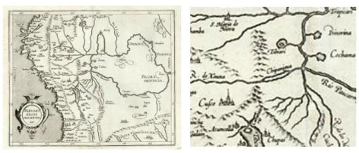
A very posterior map also shows two lakes in this still poorly documented area, always associated with the source of a river, as Paititi is in the legend.
I will not go too far on the actual correspondence of lake Tibiari with Paititi, and consider only that it is a hypothesis, trying to put me in the place of a cartographer of the time, complementing his observations with oral sources.
I can however note that Paititi is actually in the area in question, and is particularly close to one of the two lakes / sources indicated on the last map.
Interestingly, even nowadays on Google Earth, by activating the names of rivers, we realizes that the river that surrounds Paititi is labeled as: “Laguna Origen del Ma”, which I think with a small foul means ” Lagoon Origin of the Sea “. Indeed, it can be seen that Paititi is precisely in the area where the Ucayaly and the Madre de Dios both originate, without forgetting the Purus and the Jurua. These are the four largest tributaries of the Amazon, which would then have been seen by the Indians or Incas as the river that filled the “Sea”, ie the Atlantic Ocean, with water around Paititi … This would explain why this lagoon is so well known and so often cited from one end of the continent to other.
There is another map well known to all who are interested in Paititi, and which is supposed to indicate much more explicitly the location of this city:
It was built by a Jesuit in the 17th century and is preserved in the Ecclesiastical Museum of Cusco. For a very long time, I considered this card as a fantasy, the illustrated concretization of the Spanish fantasies about the kingdom of Paititi, based on no reliable information. This first judgment was largely due to the fact that it does not correspond to any existing place and thus gives rise to dozens of abracadabratic interpretations, but also that its text, at least mysterious, makes it obscure and too much subject to esoteric interpretations.
In the framework, we can read: “Heart of the Heart, Indian land of Paititi whose inhabitants are called Indians (with a play of words in-dios: in God), all the kingdoms have a border with him, but he has a boundary with none ». Top inside: “These are the kingdoms of Paititi, where there is the power to do what is desired, where the rich will find food only and the poet only will be able to open the door, sealed since always by the purest Love “. Below, on what appears to be a hill: “Here can be seen plainly the color of the song of the invisible birds”
So I scorned this card for a very long time, but recently I fell back on it after reading the work of Laura Laurencich, the researcher specializing in Blas Valera and his manuscripts. Looking at this map, a strange impression of déjà vu has seized me: the typography, the style of the drawings (sun), the use of red and black … All this strangely resembles the work of Father Blas Valera and his acolyte brother Gonzalo Ruiz.
My suspicions have been accentuated by the fact that this map is of Jesuit origin, dated from the 17th century, and signed as follows:

The “B” is clearly visible, and made me think of the initial of Blas Valera, the “G” that surrounds it would be the initial of Gonzalo Ruiz. The spiritual and very idealistic nature of the text also reminds me in many ways of the Christian utopia that they wanted to set up in Paititi.
All of this really makes too many coincidences, and I think I’m right. If there were indeed two people who knew a great deal about Paititi, thanks to their privileged contacts with the nobles of Cusco and their preference for the rescue of the persecuted Incas, it was these two men. Would the map realy indicate the location of this city?
I began to search intensively for anything that could correspond to the traces of these rivers and mountains on Google Earth and on old maps, taking into account the defects of the cartography of the time. But again, I found no river that could have been represented like this, let alone in the area where I found Paititi.
Thinking on what I knew about Blas Valera, I remembered one thing: the project he intended to set up in Paititi was highly secretive and dangerous, because it was in total contradiction to the Spanish interests governing the region. All the written traces he left in connection with this city are encrypted, have two or three possible readings, in order to conceal both the existence of the project and the localization of the city. Never before had he mentioned the so dangerous name of Paititi, except in the form of a tocapus, the secret writing of the Incas, illegible to the Spaniards.
He would never have taken the risk of leaving such a map indicating Paititi in the wild. Or at least, like his other writings on the matter, not without coding it. What code would he have used? I left on a few tracks before finding the answer. It occurred to me when I remembered that Blas Valera, in the double representation of Paititi of Exmul Imeritus who allowed me to find the city, had used the transparency of the paper to trace the same mountain seen from behind. And if this card was intended to be read by turning it, in the light of the flame of a candle, using the transparency of the support in parchment?
A simple “horizontally return the image” then reveals a completely new map, perfectly coherent:
I started a new research, and the result this time jumps immediately to me:
The high bassin of the Madre de Dios. It’s the only match :
Its few inconsistencies, such as the low mountains represented between the rio de las Piedras and the rio Manu, or in the course of the rivers, most probably arise from the difficulty of representing a ground on the basis of oral indications without ever having seen it.
But make no mistake: The maps of the time, early 17th, were as we have seen far from being perfect, the areas they represented had not been explored. On the contrary, this map proves to be in comparison with precise astonishment, practically right in comparison with the satellite views, a great first for the time, which once again confirms the privileged local sources of Blas Valera. Apart from the general arrangement which corresponds only to the Madre de Dios, certain elements are particularly convincing, in particular the shape of the route of the tributary to the left of the mountain, with this characteristic loop.
Interestingly, we finds like on the other maps an island represented to the south of the Rio Manu, which wants to represent Paititi: Indeed, it adjoins the “hill” or is indicated “Aqui …” (here …) , which itself represents the Cordillera of Pantiacolla, where Paititi is actually.
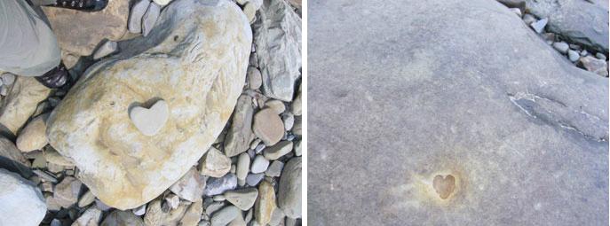
The mention “Heart of the Heart” could be related to the numerous carved hearts found on the banks at the mouth of the Rio Pantiacolla. The text on the map would suggest a ritual of entry into the territory, reserved for the poets and the purest Love.
PS: Thank you for excusing the spelling mistakes and grammar errors in English
© Vincent Pélissier 2016
The lagoon enigma
There is a recurrent character in the legend of Paititi as well as in many chroniclers: the presence of a lagoon around the mountain on which Paititi is located. From this lagoon there were, according to certain versions, a path made of black stone slabs that allowed access to the heart of the city.
However, it must be noted that, unlike all the other elements mentioned in the legend, there is no lagoon strictly speaking on the site. How to explain that? First, it must be understood, and the case is not isolated, that on this point a flaw in translation has from the beginning induced the Spaniards in error:
Indeed, the Indians speaking to them of Paititi, who lived by the rivers, had in their dialect a thousand and one words to designate the rivers. The word “cocha” in Quechua , wtich is at the origine of the misunderstood, is the equivalent of the term “para” in the Tupi Caribbean language, which means “large water” in general. In the Incas themselves “cocha” was a word meaning a lot of things, depending on the context a large “cocha” could mean the sea, but just as much a large lagoon, a lake, flooded land, or even a river…
An illustration of this confusion, a lagoon originally designates an area of brackish water separated from the sea by a sandy cordon, but in the Amazonia we find the term everywhere:
The term “Para”, the concept of “great water” of the Tupi-Caribes was therefore in most cases translated to missionaries or conquistadores by Quechua interpreters, who themselves already designated this concept by another word (cocha) with a meaning probably slightly different, all without the slightest idea, since the translators themselves did not know Paititi, from what they were really alluding to. The chroniclers could not grasp the multiplicity of meanings of this word, and if in this precise context it meant lagoon or something else. Let us go back to the original concept of “big water”, bearing in mind that the famous lagoon can therefore designate any kind of expanse of water.
Rivers run along almost every side of the rocky Paititi massif, which from many angles gives the impression of a mountain surrounded by a true moat, but we are still quite far from a large lagoon with a “Island-mountain” in the middle.
Blas Valera did not represent a lagoon, but he did draw boats that skirted the mountain, and sail to the unprotected part of the rocky bar, seemingly the only way to reach the plateau. In reality, this is also the case: the walls of the plateau are everywhere extremely abrupt, except on this rear part, after the rock bar. The principal access to the city would thus have been made by this side. And in facts, I found this main acces.
In 500 years, the living water of the Andes and the vegetation have modified the banks of the river and it is difficult to discern their previous contours. But by studying the topography in detail, two zones appeared to me to be reservoirs of water almost natural, which could in any case be created by constructing a dam, which was quite within the reach of the Incas, witch so well mastered water. The one on the left, requiring only a barrage of very small width, is at the place where the boats are drawn, and from which, according to my observations, follows an important road which ascends to the city, could have been the famous lagoon. It seems quite small here but its not at all.
Preferring to stay very careful with the data indicated by the software, I only traced the body of water that the indicated altitudes should naturally create. In reality, the river must make its way through a narrow gorge at the point marked with a red dot. If a dam is considered taking advantage of the topography of the site, using as a solid base rock blocks precipitated in the gorge from the two adjacent mountains, one can easily reach a reservoir of water 5 kilometers long and about 2 kilometers wide , which would extend before the second half of the great rock bar, and which would be fed by the river bypassing the mountain.
It remained at this stage speculation, but an interesting possibility. It is by obtaining finally a version of the drawing of Blas Valera of better quality that I noted a detail that confers a completely different dimension to this hypothesis:
Pictures from the manuscrit Exsul Immeritus Blas Valera Populo Suo, Collection Miccinelli
If it does not represent a throat hampered by rocks, a dam holding water … Again, I was surprised by the link beetween my suppositions and the evidence I find then, it is as if Blas Valera guided my thought and then provided me the solutions … This dam is well drawn on the back of the mountain, and was even placed on the side of the river where I had envisaged it.
Given the nature of the terrain, it would have created a reservoir of water of great size, in any case large enough to deserve the name of “big water”. It can be said that its artificial character would have profoundly marked the Indians of the forest, who would not fail to mention this extraordinary artificial reservoir of water, a little in the way we describe the cities that we discover by their most Impressive monuments.
We can also add that the chiriguanaes who mainly informed the Spaniards about Paititi (see below), arrived at the site, the objective of their raids, from this side from the source of the Manu, and should therefore see in the foreground this large lagoon, then behind the imposing mountain, surrounded on each side by the rivers. They did not see the other side, and supposed that the mountain was planted in the middle of a kind of immense lake.
Very interesting observation, I just realized that a legend in Google Earth gives the river that surrounds Paititi the name of a lagoon, and not just any one : “Laguna Origen del Ma”, I think with A small fault “Lagoon origin of the sea” … It says a lot about the fact that this river loop was well regarded as a lagoon, and on the other hand its importance : the origin of the sea , nothing but that … And for good reason: Paititi is in the precise zone of the birth of all the tributaries of the Amazon. We know the importance of this giant river on the South American continent, and this name suggests that for the amazonian Indians it originated in Paititi and then filled the Atlantic ocean.
I had to take a little distance and height so that the whole appears under Google Earth, but from the summit of the last forest ridge (in the top of the foreground here), the view of the lagoon and the mountain behind it had to be well more striking. The dimensions are colossal.
Add to this the fact that the few chiriguanaes whitch during their raids arrived until then had to describe this landscape orally to the members of their tribe who did not see the site, that the description was passed on from generation to generation for hundreds of years (as we will see) before reaching the Spaniards, then the difficulties of translation explained above, and you will get the only mountain of the whole continent to be in the center of a lake.
Thus, Gonzalo Solis de Holguin, the one who followed the chiriguanaes from Santa-cruz in Bolivia to the land of the “Toros”, which appears to be north of the plains of Mojos (south-est of Paititi) collects information on a great lord reigning further north, called Yaya, leading a people dressed “like us” called “raqui” and armed with fronds “like the Indians of Peru”. He also learns that where the Yaya lives, a large lagoon surrounds a high mountain.
Confirmation by the maps
The mystery of the lagoon solved, let us see to what extent this geographical feature, so often quoted in the descriptions, could have directed us from the outset on the location of Paititi.
I am passionate about old maps. If there is one thing that one can immediately realize by studying them and comparing them to Google Earth, it is that they are absolutely all false, and in general quite widely, that is what makes their charm. It is understandable that, at the time when it were carried out, the precise datas were badly missing, so their authors tried to compile as much as possible informations derived from direct observations in the near field, more or less clear reports, and for areas which have remained untouched by any exploration, of oral indications of premises.
It is this last point that interests me. In spite of the vagueness of this information probably collected orally with great difficulty from the Indians of the forest not accustomed to cartographic rigor, one can still discern some useful clues. We know that they knew Paititi, and described it as a mountain surrounded by water. If a cartographer questioned them on his site, it was thus that he had to represent it then, placing it in a sector indicated by them taking as references the great mountains or the important rivers.
Now, this is what I noticed on several maps:
We can note the representation of a lake with an island in the middle, called “Tibiari”. The course of the rivers is completely false, since the area was very little seen not at all explored by the Spaniards in 1597. However we can still recognize the high basin of the Madre de Dios / Madeira below, and the top Ucayali basin above, whose most southern arm is the Urubamba. The two high basins are actually not connected as on the map, but we might think that at the time the rio Manu seemed to make them communicate. Finally, the location of Cusco and Titicaca make the nearby mountain range of Pantiacolla identifiable.
No lake in the area between these four landmarks exists on the satellite views, which suggests that the indication was oral. The representation of an island makes one think clearly of the idea of Paititi that the Indians of the forest were made. And indeed, Paititi is in this area.
I carried out long research on the term “Tibiari”, finally finding in an old work that it corresponded to the name of a tribe on which I could not gather any information. In Guarani, “Ari” would mean “above” or “on”, but I did not find what “Tibi” could refer to etymologically. I am not persuaded that the origin of the term is Guarani…
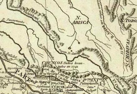
A very posterior map also shows two lakes in this still poorly documented area, always associated with the source of a river, as Paititi is in the legend.
I will not go too far on the actual correspondence of lake Tibiari with Paititi, and consider only that it is a hypothesis, trying to put me in the place of a cartographer of the time, complementing his observations with oral sources.
I can however note that Paititi is actually in the area in question, and is particularly close to one of the two lakes / sources indicated on the last map.
Interestingly, even nowadays on Google Earth, by activating the names of rivers, we realizes that the river that surrounds Paititi is labeled as: “Laguna Origen del Ma”, which I think with a small foul means ” Lagoon Origin of the Sea “. Indeed, it can be seen that Paititi is precisely in the area where the Ucayaly and the Madre de Dios both originate, without forgetting the Purus and the Jurua. These are the four largest tributaries of the Amazon, which would then have been seen by the Indians or Incas as the river that filled the “Sea”, ie the Atlantic Ocean, with water around Paititi … This would explain why this lagoon is so well known and so often cited from one end of the continent to other.
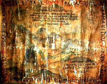
There is another map well known to all who are interested in Paititi, and which is supposed to indicate much more explicitly the location of this city:
It was built by a Jesuit in the 17th century and is preserved in the Ecclesiastical Museum of Cusco. For a very long time, I considered this card as a fantasy, the illustrated concretization of the Spanish fantasies about the kingdom of Paititi, based on no reliable information. This first judgment was largely due to the fact that it does not correspond to any existing place and thus gives rise to dozens of abracadabratic interpretations, but also that its text, at least mysterious, makes it obscure and too much subject to esoteric interpretations.
In the framework, we can read: “Heart of the Heart, Indian land of Paititi whose inhabitants are called Indians (with a play of words in-dios: in God), all the kingdoms have a border with him, but he has a boundary with none ». Top inside: “These are the kingdoms of Paititi, where there is the power to do what is desired, where the rich will find food only and the poet only will be able to open the door, sealed since always by the purest Love “. Below, on what appears to be a hill: “Here can be seen plainly the color of the song of the invisible birds”
So I scorned this card for a very long time, but recently I fell back on it after reading the work of Laura Laurencich, the researcher specializing in Blas Valera and his manuscripts. Looking at this map, a strange impression of déjà vu has seized me: the typography, the style of the drawings (sun), the use of red and black … All this strangely resembles the work of Father Blas Valera and his acolyte brother Gonzalo Ruiz.
My suspicions have been accentuated by the fact that this map is of Jesuit origin, dated from the 17th century, and signed as follows:
The “B” is clearly visible, and made me think of the initial of Blas Valera, the “G” that surrounds it would be the initial of Gonzalo Ruiz. The spiritual and very idealistic nature of the text also reminds me in many ways of the Christian utopia that they wanted to set up in Paititi.
All of this really makes too many coincidences, and I think I’m right. If there were indeed two people who knew a great deal about Paititi, thanks to their privileged contacts with the nobles of Cusco and their preference for the rescue of the persecuted Incas, it was these two men. Would the map realy indicate the location of this city?
I began to search intensively for anything that could correspond to the traces of these rivers and mountains on Google Earth and on old maps, taking into account the defects of the cartography of the time. But again, I found no river that could have been represented like this, let alone in the area where I found Paititi.
Thinking on what I knew about Blas Valera, I remembered one thing: the project he intended to set up in Paititi was highly secretive and dangerous, because it was in total contradiction to the Spanish interests governing the region. All the written traces he left in connection with this city are encrypted, have two or three possible readings, in order to conceal both the existence of the project and the localization of the city. Never before had he mentioned the so dangerous name of Paititi, except in the form of a tocapus, the secret writing of the Incas, illegible to the Spaniards.
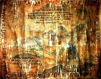
He would never have taken the risk of leaving such a map indicating Paititi in the wild. Or at least, like his other writings on the matter, not without coding it. What code would he have used? I left on a few tracks before finding the answer. It occurred to me when I remembered that Blas Valera, in the double representation of Paititi of Exmul Imeritus who allowed me to find the city, had used the transparency of the paper to trace the same mountain seen from behind. And if this card was intended to be read by turning it, in the light of the flame of a candle, using the transparency of the support in parchment?
A simple “horizontally return the image” then reveals a completely new map, perfectly coherent:
I started a new research, and the result this time jumps immediately to me:
The high bassin of the Madre de Dios. It’s the only match :
Its few inconsistencies, such as the low mountains represented between the rio de las Piedras and the rio Manu, or in the course of the rivers, most probably arise from the difficulty of representing a ground on the basis of oral indications without ever having seen it.
But make no mistake: The maps of the time, early 17th, were as we have seen far from being perfect, the areas they represented had not been explored. On the contrary, this map proves to be in comparison with precise astonishment, practically right in comparison with the satellite views, a great first for the time, which once again confirms the privileged local sources of Blas Valera. Apart from the general arrangement which corresponds only to the Madre de Dios, certain elements are particularly convincing, in particular the shape of the route of the tributary to the left of the mountain, with this characteristic loop.
Interestingly, we finds like on the other maps an island represented to the south of the Rio Manu, which wants to represent Paititi: Indeed, it adjoins the “hill” or is indicated “Aqui …” (here …) , which itself represents the Cordillera of Pantiacolla, where Paititi is actually.
The mention “Heart of the Heart” could be related to the numerous carved hearts found on the banks at the mouth of the Rio Pantiacolla. The text on the map would suggest a ritual of entry into the territory, reserved for the poets and the purest Love.
PS: Thank you for excusing the spelling mistakes and grammar errors in English
© Vincent Pélissier 2016