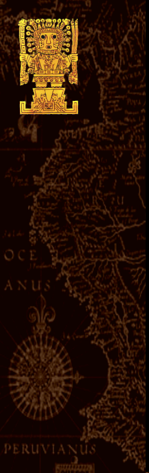


The discovery of Paititi
Paititi is the XXI century still actively sought by several teams of archaeologists. Currently, a team headed by French archaeologist Thierry Jamin is at the forefront of this research. 6 years ago, it was his first blog witch made me aware of the possible reality of the myth of Eldorado, and of the existence of Paititi. I had then began to dig about this exciting subject by reading on websites and blogs, digital libraries and archaeological records online in search of information, as I like to do during my free time.
I quite quickly concluded from reading the chroniclers of the time that it was likely that a great city did exist in the forest. A ensemble of elements going in this direction:
To me the simple fact that the Antisuyu is mentioned as one of the four provinces of the empire necessarily implied a major regional capital. I learned that the Incas had a contrasting vision of Antisuyu, both considered a land populated by terrifying savage tribes, mysterious and sacred place where the spirits of their ancestors took shape in the form of wild animals, but also as a tropical paradise where nobles relaxed regularly in their palaces. In fact there were two Antisuyu: the even mountainous one in surroundings of Cusco, and that of the Amazon plain. More and more researchers argue that the Incas widely frequented the Amazon region, where remains are gradually recovered, as the small city of Mameria.
The Inca Túpac Yupanqui would have led an expedition by fighting Manu tribe, name of an existing national park, and its predecessor Pachacutec have explored around the Madre de Dios River, a region also bears the name today. They would both have founded a network to ensure a supply of tropical products that the nobles of the capital particularly appreciated: coca, medicinal plants and exotic fruits, but also the colored feathers that were worth very expensive, some rare woods, gold, silver, animal hides … To me, an important commercial center was bound to exist in this area, allowing these products to transit to the capital.
The cities founded also had a military purpose: to control the incursions of tribes Anti and Chuncos was paramount, so close to Cusco. Hiram Bingham considered that the city of Choquequirao (northwest of Cusco) was one of the border fortresses, like Machu Picchu, but were there no others further east? Moreover these two cities do not seem to have had a military vocation despite their situation, because it would have been too much simple to cut the aqueducts that brought their water to make them surrender. Simple rear bases? Where was the real fortress that protected the empire in the east or the north? I imagined it on a final height, overlooking the forest, and for both mandatory door and principal commercial interface between the world of the mountains and the one of the forest.
Where Manco Inca have gone starting from Cusco with his treasure? By Lares it seems, north of Cusco. Then we lose his track for almost a year. A column of 20,000 llamas carrying gold would have crossed the mountain near a certain Vilcabamba. Vilca means “grandfather” or “sacred” in Quechua, Bamba stands for “land”. The sacred land of the ancestors… Today a town of that name exists, it is located 80km northwest of Cusco. But archaeologists seem to think it was not the Inca Vilcabamba. This one is not identified to date, or rather, several cities are possibly identified as such, including Choquequirao, Machu Pichu, and a ruined city located in the forest further north: Espiritu Pampa. The Spanish knew Vilcabamba “the old”, as the capital of the Inca resistance during the last years of the conquest. But Tupac Amaru, the last Inca, would have burnt this city. To go where ? It must probably exist another city, unknown by the Spanish in the heart of the forest.
All of that remained very vague. The search area was quite extensive, if not huge, and besides all archaeologists were going in a different direction.
Thierry Jamin then explored the beginnings of the valley of Lacco, which start in the outskirts of Cuzco to go north over a hundred kilometers, along the forest. His discoveries, if they remained just un little spectacular, nevertheless remained very interesting archaeologically speaking and proved an Inca occupation of this valley , inexplicably neglected so far by researchers as by human settlement.
Unlike Thierry, I saw this valley not as the desired site, but as a route across the vast Inca empire. So I started my researches much farther at the north than him. Not having Italian téléspacial partners nor advanced satellite images as his team, but simply Google Earth, I spent hundreds of hours studying every detail of this high valley to try to find a clue that would be useful to him.
A mountain pan finally attracted my attention: Well exposed, a little steep but a few rugged, irrigated in the middle by a stream, it especially showed traces of an important ancient terraced crops.
The place was located far from any known Inca city, as this important food production seemed to me to be a useful element. I communicated these findings to Thierry Jamin through his profile on a well-known social network, but that no response had never occurred to me then somewhat discouraged me to conduct more research to help him.
Several years passed before I’m interested again about. Meanwhile, my archaeological leisure had led me to other shores, those in the south of France where I live and the many Greco-Roman remains still to discover in. I concluded from this experience that one of the secrets to localize lost sites was follow the ancient paths to find their junction points, and I had drawn the most complete and synthetic map of all we knew about the ancient occupation in Narbonne Gaul: remains, old maps, written accounts, place names, topography…
It is in this light that I studied again the Peruvian Andes early 2015. Taking my research where I had left, I then found that all current routes of the region, following the ridges of natural mountain ranges, seemed to converge to Chancamayo and Sahuayaco. From both of this places if you look closely, leaving two passages that allow to go to the next valley. The gap leaving Chancamayo goes directly to the mountain face with traces of ancient crops that had interested me a few years ago.
By studying again the site in detail, I found that a path started from the mountain pan, on the opposite side of the valley, towards the forest area.
This path was quite visible on Google Earth, even high enough, which suggested a important attendance. However, no traces of habitations or of any significant settlement for kilometers. In addition, the high gradient exclude whether a roadway. I have concluded that this track could be the remnant of a relatively important Inca path.
I traced this path almost mechanically, losing it here, finding it highest on the ridge he followed, to the north. At this point, it was to me just one of the many Inca paths that roamed the Andes, and that I intended to map.
But something has upset this vision: Following the path direction while it entered the wet zone, I suddenly saw…
A pyramid.
It was totally unexpected, unbelievable.
I spare you the state of excitement which was mine at that time. I changed and changed again the Google Earth angle of view on all axes , but which seems rather be a pond or a tree (the definition of the image is poor, and the building totally lost in the immense mountainous forest) had indeed perfectly four faces erected on three levels and topped by a small dome, all covered with vegetation.
Is this site was listed, known? There was unlikely given the lack of interest and research which had been this high valley, and especially the lost area where had led me the way. An audit is required, however, and I studied eagerly the topic.
I learned from my research that the Incas built a very few number of pyramids, unlike the Maya and Aztecs. The rare Inca buildings of this kind we have found, for example that of Rumicolca just south of Cuzco, seemed to the archaeologists have more held the role of indication signs around large cities, and not worship or burial.
And no trace anywhere of a pyramid discovered north of the valley of Lacco.
From that moment, I knew I had made a fantastic step forward, and I worked days and nights to develop. I had no idea what would result.
I should also mention an anecdote: While, exhausted, I fell asleep in front of the screen, I had a very realistic dream, those that mark us. I was on that road that rose terribly, out of breath. Before me, about fifty meters, the Inca was guiding me, alone, calm, without a word. When I was out of breath, he turned around and waiting. What is strange is that at the time I imagined an Inca covered with gold or something like that, whereas in my dream, he wore a tunic in brown tones and a kind of simple crown. Later, I discover that it was quite like that the Inca was dressed.
Awake this time and looking more than ever determinate to pursue the draw of the road, I was soon faced its demise in the vegetation, which gradually covered the mountain range. Google Earth zooming out, the track already made became clear to me. It was relatively straight, and went due north, taking a mountain ridge.
Why did the Incas used thus ridges like this then we use the valleys as communication ways? This question struck me, and after some reflection I came to the following conclusion: When we look well the relief of the Andes, we understand that just a few valleys communicate. To use it as ways would mean so constantly climb and descend 4000m high mountains… So pass from a ridge to the other allows being safe from this ordeal. In addition, the wet zone valleys of the Andean are systematically terribly hampered by raging rivers, huge screes, impenetrable vegetation, making them almost impassable.
The ridges so as paths. I then traced a hypothetical continuation to my Inca path, following the crest she borrowed northbound. The ridge ends in declining at the edge of the vast Amazon. It died at the foot of a last spur, standing like a wall between the world of the mountain and the forest, east / west perpendicular to my path.
A wall? Not exactly. At the exact spot where my ridge ends, a break in this great natural rampart, unique for kilometers to the east and west, is formed by the course of rivers that meet at this point.
Because it is not one, but three and even five ridges from all directions that come together and decline at that location. A giant funnel, a unique natural junction point in the entire region.
Five ridges, so five many potential paths from all parts of the empire, which end in this point from which the river becomes flat, navigable, and therefore a communication way such as the one the Indians still use to move in the great forest .
The “Amazon door” I thought looking at the hole in the wall, and further, at the green ocean.
And right behind that door… A huge fortification. A natural citadel seemed cut across mythological giants. A final burst of pride of the Andes, coming from nowhere, isolated from the bass surrounding mountain ranges and much more imposing. In fact, a huge rectangular plateau, with vertiginous flanks, surrounded by a moat formed by the rivers that almost completely bypass it.
The gatekeeper of the Andes.
And an ideal spot for a military and commercial site of first importance.
Only assumptions … Because apart from this favorable topographic pattern, often encountered in my Gallo- Roman studies, there was nothing to substantiate my hypothesis, and for good reason : Absolutely everything was covered with lush vegetation.
After having unsuccessfully sought a logic of occupation of the place for hours and put some landmarks of notable points, I had to accept to the obvious: I had arrived at the end of the possibilities for a french internet user installed in his living room.
I stepped back on Google Earth to see all of my benchmarks and the work done from my pan of mountain cultivated, after many sleepless nights. And then a landmark, a bit out and of a different color, caught my attention. What had I wanted to signal?
A rocky promontory at the end of a mountain range, vaguely rectangular shape and fairly flat, with three small lakes … all came back to me suddenly. In 2014, Thierry Jamin had published on his Facebook page a picture of the site that would like to explored in 2015. Knowing perfectly the area, I immediately recognized the geographical location and had marked it with a landmark a year ago, while as from time to time I just stood aware of his progress.
How did I not seen it before? How, could it be that Thierry Jamin, I left years before in the Lacco valley beginning near Cuzco , is now a big hundred kilometers further north, on the nearby mountain of my strong keeper of the Andes … what had brought him so far, precisely in this absolutely lost area?
Picture from Google Earth
My enthusiasm started up again. On reading his blog, I learned that he was absolutely convinced that Paititi was on this rocky promontory, because he had managed to decipher the Pusharo petroglyphs, a set of engraved signs that he still considered as major. In the light of the setting sun, like a movie, he managed to discover new symbols, which had transformed his reading of petroglyphs : it was in fact, according to him, a great card for those who went to Paititi, which it clearly indicated the location of this city.
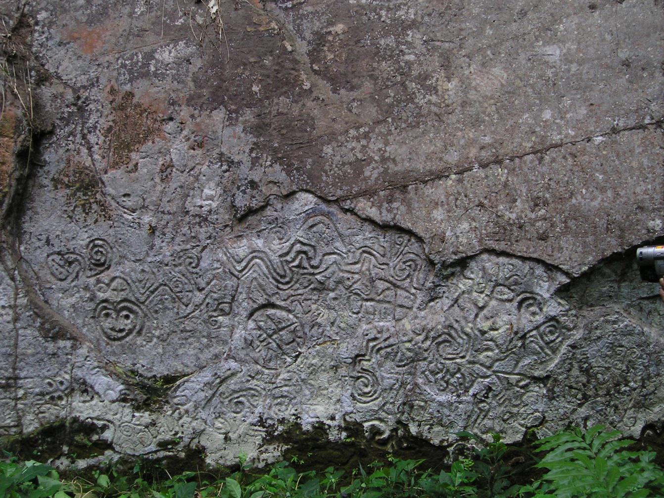
Photo : Thierry Jamin
And this card had led him… at 10km from my strategic plateau.
Local Indians have confirmed to him that significant ruins exist in the area.
While not being a formal proof, the results of his work were a major element that suddenly accredited my hypothesis. Admittedly, we did not have the same opinion about the site: I found his headland too inaccessible and impractical for a commercial city, too small to establish food crops on the scale of a great city … I thought my plateau much better served by rivers, Andean roads through the “door” and the mountain range to the south, larger, more accessible by its rear face, brief more strategic.
Also I found on the plateau five peaks, and one of which is the entire region highest. Again, I tried to put myself in the mind of the Incas: They worshiped the mountains. All we know about them proves their beloved dominant peaks.
Was he right or was it me? Anyway, the area suddenly became incredibly promising, and I felt closer to Paititi. But always I missed THE proof.
I then restarted intensive documentary research on the lost city, in search of a clue. I got somehow translations of ancient texts, from Spanish chroniclers, mostly Jesuit priests, I explored in detail everything related to Paititi the web, from the most fanciful drawings and fantastic stories to academicians negations and even alien duffs debates on forums …
I constituted a kind of file, including text, pictures and interesting hypotheses. I noted as so many other things a description of Paititi made by a chronicler, probably from a witness or a local rumor, stating that Paititi was on a fist-shaped mountain with five peaks, at the end of an isolated canyon in a valley shaped as a volcanic cone. The place would have its own microclimate. The city would have been at the source of a river falling into an abyss, creating a waterfall.
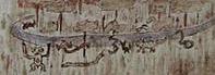
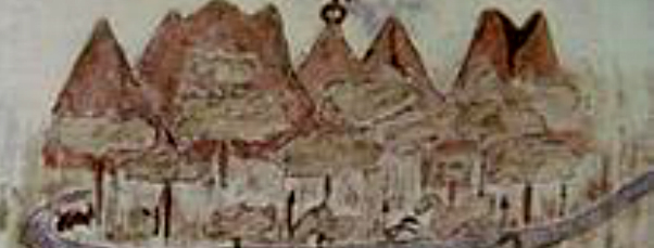
Among the fanciful representations of Paititi, one caught my attention: it seemed older, drawn on parchment. The almost naive trait of the mountain represented in two different ways had heckled me, as well as the small animal drawings listed below, as dancing round in two rows.
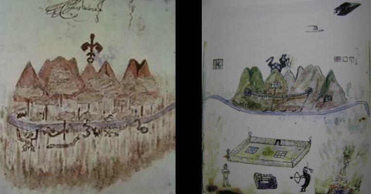
Pictures from Exsul Immeritus Blas Valera Populo Suo, Collection Miccinelli
I did not pay more attention on it and, in desperation, turned once again to the careful observation of my plateau. I then exploit a possibility of Google Earth that I had neglected so far : to see from the ground.
I imagined myself as an inca from the mountains discovering for the first time the extent of the Amazon forest, so I placed myself at “the door of the Andes” I had supposed, at the exact location of the opening in the rampart.
It was probably the best idea of all my life.
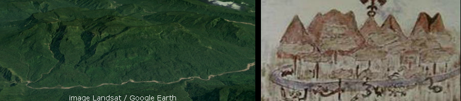
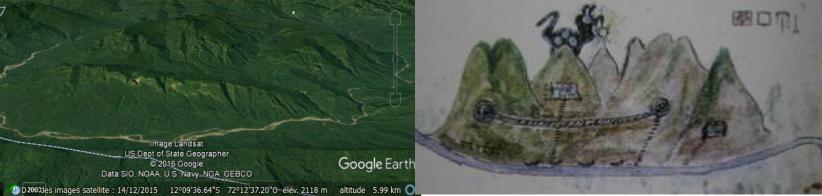
Immediately, the likeness of my plateau from this point of view with the drawing on parchment struck me: five peaks, isolated from any other mountain range… It’s important to understand that in the Andes, which consist of mountain chains, that type configuration in 5 isolated peaks like in the drawing is extremely rare, not to say unique.
Especially, they were located in exactly the same manner as in the first drawing. This one, which was first appeared to me as childish, proved opposite to extremely precise. It noted even by a strange weather vane condor shaped one of the summits, which corresponds exactly to the highest mountain of the plateau, and of the region, which I mentioned a little earlier. Everything is there: the twin mountains, the one with three small peaks, the one which opens in two …
Five peaks … then I thought of the description of a fist-shaped mountain.
Initially I found the plateau seemed viewed from up to a fist, but the Incas did not have this view … The second image explains much better the metaphor used by the witness to describe the mountain to the chronicler: put your right hand in front of the picture and compare with it. Even the veins are in the right direction.
The river also: it bypasses the mountain plateau on the drawing exactly as in reality, its source is exactly well placed, as can be seen on the following views :
In the written description of Paititi, the river was supposed to spring from the top of the mountain and fall into a kind of abyss , forming a waterfall, before rounding the massif.
The river skirting the mountain actually has a tributary that originates directly on the plateau. The image from this angle of view is not very eloquent, but be aware that the top of the source is at 2600m altitude, and that in its first section, the water makes a 700m sharp drop and so… cascades. It then joined the river at an altitude of 1250m as a torrent.
Finally the isolated canyon that arrive to the mountain of Paititi as described…
… mountain that is itself compared to a volcanic cone because of the round shape of the valley that surrounds it :
I understood after some time that the second drawing was actually the representation of the rear view of the plateau, from the hills of the forest. Again, all peaks are well placed, even if in a desire to be understood the author principally returned his previous drawing. Or rather drew the back using the transparency of the paper.
What had seemed to me to be a rope bridge actually represented unambiguously the strong and frank about 2/3 the length mountainous bar on the back of the plateau, which guards the access to the5 peaks via a sort of valley which separates it from this ones.
It’s very strange, in the drawing we can see through, but we can imagine that the representation was made from memory or, more certainly by following oral directions to someone who saw Paititi, and would have described with his words in local language misinterpreted, or described thanks to the form of a fist overcame by a link to image the rock bar, which would have been confusing .
Still, everything fits.
Absolutely everything.
Where are these drawings from? Who made them? Is this a reliable source?
I found with great difficulty the site which I had extracted that representation and get a name: that one of the codex which it is drawn.
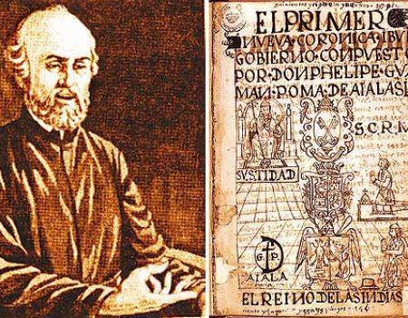
The story of this book is amazing. He was found only in 1996 in a dusty library of Naples, by Clara Miccinelli. University of Bologna researcher Laura Laurencich Minelli acquired it and published a study about it. Its author is a chronicler of the time of the conquest, a priest of the Jesuit order named Blas Valera.
The story of this man is very interesting and makes him perfectly credible: son of a Spanish captain and an Indian, he is one of the metis from the first generation; he had the two cultures in him. In other words he is one of the only “Incas” that actually had a written record… He was ordained a priest in 1574 and, like many other chroniclers, he was responsible for the compilation of information relating to pre-Hispanic civilization. Early contact for this purpose with the sages of the Inca nobility in the “Name of Jesus” brotherhood in Cuzco, he would have benefited from information of very first order, much better than those collected by the Spanish chroniclers subjected to the Vice-royalty. Accused of heresy for having taken position too favorably in his writings for the Inca, he will be condemned by the Jesuits themselves and send to Spain.
According to the book, entitled “Exul Immeritus Blas Valera Populo”, his works were stolen on that occasion by the religious order, before being censored of all mentions of the atrocities committed by the Spaniards. They’ll however become essential references relating to Inca history, as his “Historia de occidentalis” according to him watered by Garcilazo de la Vega in his famous “Royal Commentaries” in particular removing a passage describing how Francisco Pizarro assassinated Atahualpa’s generals inviting them to drink poisoned wine…
We also learn in this book that Blas Valera, declared dead in Spain, is actually returned to Peru. The major work on Inca history, the famous “Nueva coronica y buen gobierno” by Guaman Poma, would in fact have been his work (see the detailed history of Blas Valera below). At the same time he wrote the manuscript “Exsul Immeritus” to do justice for himself and to his mother’s people too.
But in my point of view, the real interest of this book is the two views of Paititi. This is THE single work from this period representing this city witch exists.
Like all that has been discovered recently and which calls into question the foundations of the secular works of the domain, this manuscript is still contested by the academy. By proving that these drawings are perfectly accurate, and undoubtedly represent a concrete place, I think that its detractors will have to reconsider their position. Especially since, as we shall see in the confirmation of the discovery, other distinct sources prove in a significant way that it is indeed Paititi that is indicated in these drawings, and therefore Blas Valera had well information of the first order. And was in no way flabbergasted.
Five centuries later, through god only knows where, this is the book-will of this man who brought me a proof beyond all my expectations. This is probably the most credible source for this remote and troubled time.
By digging about the descriptions of Paititi we have received, I also fell, among others, that one of the missionary Francisco Cale (1686), which probably contains the testimony of a local: “the kingdom of Paititi is reached after 5 day by walk from Cuzco. The city Pantiacollo, the central heart of the mythical kingdom of Paititi, is called by the Incas Paiquinquin Qosqo, which means the twin city of Cuzco.”
How is called today the small mountain range at the north end of which is my plateau? ” Cordillera de Pantiacolla”… Particularly evidential, isn’t it?
“My” mountain is situated 120 km north of Cusco, either, through the ridges and highlands of the Cordillera Pantiacolla, about 5 days walk.
I then deepened my knowledge of the Inca history, examined in detail, looking for the slightest geographical indication can still strengthen my discovery. I finally arrived at my purposes :
Vilcabamba, the famous, was founded by Tupac Inca Yupanqui, at the end of a military campaign in Antisuyu. The Inca himself would have passed by Pillcopata, and would have sent one of his generals on Paititi by a parallel road. The campaign was a dismal failure. Vilcabamba was founded at the ultimate point reached by the Inca troops, after a pledge of peace with the Great Ancestor ( yaya ) Lord of Paititi, as to commercially connect this city to the capital Cusco as to monitor it. So Vilcabamba was not far from Paititi , between it and Cusco.
Where it gets interesting is when a century later the Spaniards go to capture the last Inca Tupac Amaru. The Spaniards knew exactly where Vilcabamba, official seat of the resistance, was, because thez sent many emissaries in this place. Chroniclers relate that their troops pass through Choquechanca, crossing a pass, and arrived on ..the Cordillera de Pantiacolla, where they took possession of small fortresses. And then, in no time at Vilcabamba.
So if we summarize: Vilcabamba was founded nearly Paititi linking it to Cusco, and Spanish to reach Vilcabamba went through Choquechanca then Cordillera Pantiacolla.
The Cordillera of Pantiacolla is also mentionned in an ancient Inca legend : Inkarri (the Inca king) had retired after the founding of Cusco in a region bearing that name, in a town named Paititi. I also indicated the Madre de Dios region, where officiated in the seventeenth century Jesuit Father Andrea Lopez, who told his superiors have been in contact with the Inca, lord of Paititi.
Which would give us in a schematic representation … exactly what we can see on a map if Paititi is on my plateau.
Arrow 1 & 2 > Cordillera of Pantiacolla and cordillera of Paucartambo
Arrow 3 > Paititi’s Plateau
Arrow 4 > isolated canyon previously described
Arrow 5 > North end of the Cordillera Pantiacolla and probable location of Vilcabamba
I can’t say whether the landmark I indicate is or not the real remains of Vilcabamba, burned by Tupac Amaru before his capture, but in a likely location, those traces caught my attention: The black marks are geometric, but also above that point starts a ridge path which goes to right to Paititi, and that has kept the legacy of a large attendance (picture2)
I stopped to blow after days of self-denial. I read and reread everything you just discovered. The legends and testimonies of natives, descriptions of columnists, the historical facts, the ground… These incredible drawings of Paititi… ALL matches perfectly.
Blas Valera … It is thanks to him that I managed to localize Paititi, nearly without a doubt. He realized a full compliance with field drawing. Aside from these animals. It was strange… I wondered how his first drawing could be so precise and fanciful at the same time, with these small animal figures that seemed to dance on the mountainsides.
On the sides … I thought about the geoglyphs of Nasca. And also the beautiful geoglyphs found by Thierry Jamin near the site of Pusharo :
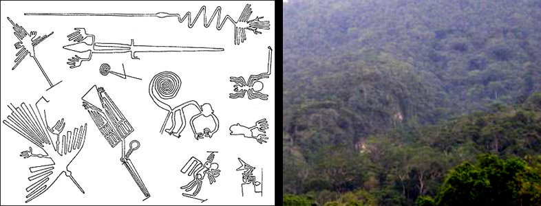
By scrutinizing the plateau from any angle, I seemed to have discerned atypical lines in the vegetation… Could it be that these drawings are not an attempt to language, since the father Valera wrote perfect Spanish and Latin, but a representation of physical patterns on the site?
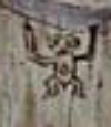
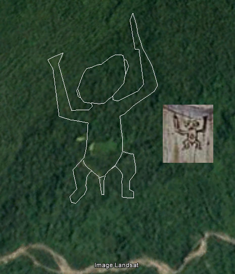
Moreover, I note that the first formers seemed to be seen in transparency, unlike the others who are “plated” on the mountain pans. The two drawings rows could match with the two sides of the valley that surrounds the plateau… I choose then the first one I identified as “the monkey” or ” the man” and looked if I could see a trace exactly where it should be, according to the drawing.
And again, intuition or incredible luck …
The geoglyph is there.
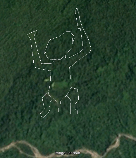
Exactly the right place. Certain parts are perfectly visible, the head, an arm, which helps me to roughly discover the complete form and to plot it. The rendering is pretty bad on the screenshots below, but by showing / disappearing the plot in Google Earth (2011 version of the software), and playing with the incline of the terrain and « traveling views » in motion, it’s much more obvious.
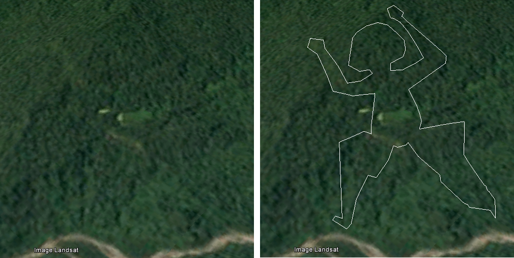
12°12’40’’ S / 72°08.42’’ O , picture Landsat / Google Earth
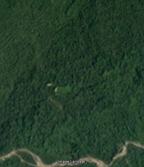
Even the esplanade at the level of the navel, which remains free of vegetation, because probably paved, is represented. And also the sex, which I have not traced but can clearly be seeen. I finally held my ultimate proof. A real proof of ground, unique, just as convincing as if I had gone myself on the site. And besides, on the site, we probably would not see it.
By multiplying the angles of view, and with a little work, I got to better define the contours, especially legs which are by far the most difficult part to discern. Here is the result :
To show you even without Google Earth that I did not invent any layout, I invite you to save on your computer the following two images, which are exactly the same size. Go and come from one to the other in any image reader, and you will see what the layouts are from.
And other geoglyphs … One by one, I find them all. In fact 10 of 12, but I ‘m sure that with a better image definition I could find the last two. Some are barely visible, much less than the “monkey”. Streams lines, ground, trees that have grown or not, everything is mixed and it’s difficult, I’m not sure of all, but even with all the bad faith of the world I never could find 10 forms so similar to the drawings in the same order, and so close.
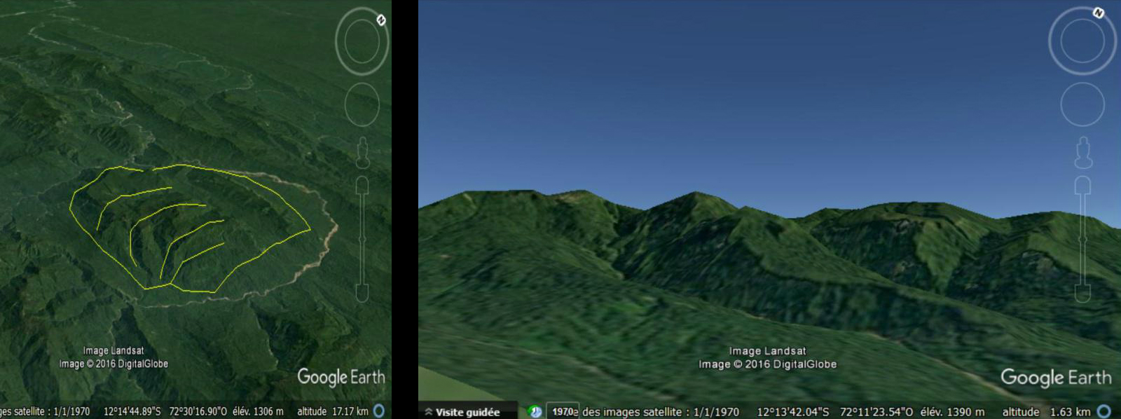
So in the end, 10 huge geoglyphs (the largest, which I called “Condor” measures … 2.5km) patterns on both south and southeast sides valleys of my plateau.
What an awesome site. What a sight it must have of these colossal animal representations from the plateau, and more from the bed of the river, on which we also see clearly drawn crafts. The impression on arriving at Paititi was to be striking… It is really the mystical city of knowledge of the Inca Empire, as legend calls it.
Needless to say that at this stage, for me the question was no longer permitted. I’m used to separate my bit atypical intellectual life and the rest of my social life, but at that moment, the two were deviating dangerously. I had not slept for days. I was in a kind of parallel reality, it was hard to realize.
I was the only human since 500 years knowing where Paititi is.
The Eldorado.
But to return: the days that followed, to clear my head facing all that pressure, I decided to dive back into Google Earth. I went from discovery to discovery.
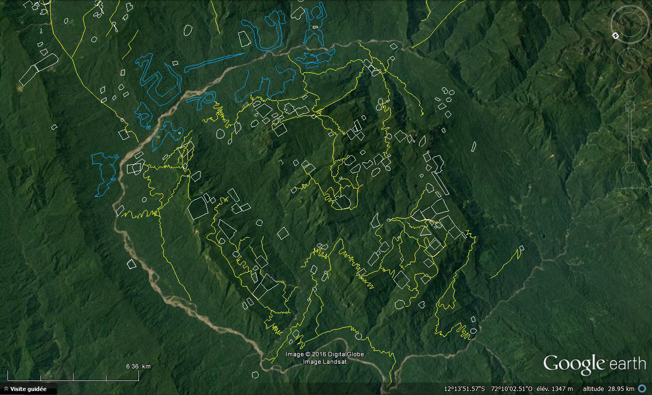
I replaced pins of remarkable points by tracks, those of possible fields, enclosures or buildings when it was what I had wanted to point, because of the visible rectangles or square shapes in the vegetation, this one having a pushes or color differences remarkable in some place.
I also traced some paths meet, visible here and there on the slopes shave peaks. Despite the average image my eyes gradually accustomed to detect these traces. Better, I mastered increasingly the software, and managed to increase the viewing angles, lightings, movements of “traveling”, which allowed me to discern more traces.
A road, an enclosure, a road, a building, and again, and again… the topography helped me to understand the logic of the city: the Incas were excellent climbers, and indeed the whole site is steep but they could not march vertically, so I found the zigzag of ascendant paths. Similarly, those connect logically buildings and living centers on the plateau, the shorter, especially in avoiding going up and down unnecessarily.
Some buildings are really built on the rock face, but when you know the other Inca sites, nothing surprising. In the end, this is a city that I discover, little by little. I began to discern different neighborhoods, it makes me think … to the drawing.
I realized then that I had taken for simple spots on the design of the mountain were actually representations of the various population centers that I find on the plateau. The major roads that climb the sides of the plateau are also shown in black. Blas Valera realized a real map.
We can see in the field and on the drawing four quarters. The set is especially great. Four districts … as in Cusco, only city able to compete in size with it.
Pantiacollo, the central heart of the mythical kingdom of Paititi, is called by the incas Paiquinquin Qosqo according to Francisco Cale, meaning the twin city of Cuzco.
The second design also details a kind of chamber, an enclosure, which must be the religious center of the city, as the Curicancha (sacred area) was in Cusco. It is placed on the back of the dominant mountain marked by an animal symbol, holding Inti the sun in his mouth. The buildings contained therein are detailed also around
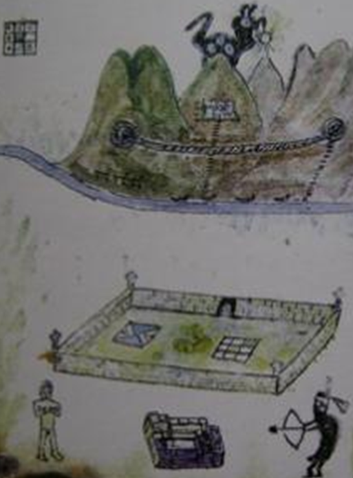
The symbol on the left is a Tocapu representing the Tahuantinsuyu, the Inca Empire, divided into four parts. According to Laura Laurencich Minelli, it translates as “Cuzco and its limits”. The one on the right means: “divided land of the Tahuantinsuyu”, its central part (Cuzco), and the other colored part is the Antisuyu. In accordance with the language of the tocapus presented in Exsul Immeritus, this means that Cuzco was transferred there and that the Tahuantinsuyu had been reduced only to the Antisuyu.
It may be noted that a group of buildings in the heart of the compound seems to be made of gold. If there is a treasure in Paititi it is probably there, in this sacred place. The citadel represented is perhaps the detail of this building, with a clear part at the top (Hanan) and a dark part at the bottom (Hurin), symbols of the politico-religious inca duality. At the top of the drawing, it is written in Latin: “Dominator, here is gold that has not been stolen, here is freedom that has not been torn away, and entrusted to you by the people of Tahuantinsuyu”.
The suspension bridge potentially represents as we saw the rocky bar which keeps access to back of the five mountains. However, for a sake of clarity, maybe that this bar was simply not represented, and that there was indeed a suspended bridge connecting the first and fourth mountains. On both sides seem to be represented two caves. According to the researcher Laura Laurencich Minelli, a great specialist of the manuscript from which this representation is drawn, these caverns would be two hells reserved for christians and indigenous people respectively. This last hell bears the name Supayhuachi, synonymous with Upaymarca (the dark world of shadows); A Jesuit letter of 1614 indicates that to enter the Upaymarca, the souls had to cross a bridge of woven hair that could be that of the illustration.
A small drawn hand pointing to a form in which it is written in capacquipu (another form of Inca script) a verse from the Apocalypse (6, 9-10) which refers to the destruction of the indigenous world and witch calls to the justice. To summarize, this drawing informs us that the Paytiti is the new center of what remains of the Inca Empire, which receives the Tahuantinsuyu gold to preserv it from the Spaniards, but is also an hell (for the traitors) in two versions : for christian and indigenous.
It is difficult to distinguish precisely these elements on the face of the mountains covered with vegetation. Would the enclosure be underground? This would go in the direction of Paititi’s descriptions, witch insist about the many tunnels and caverns on the mountain, but also testimonies of Indians who report to the Jesuits see “the guardians of the Paititi sanctuary called Paco-Pacuris, dressed in white robes coming out of Caves in the mountains “. Today, in the precise area where I discovered Paititi, there would still exists an unknown Indian tribe named … the Paco-Pacuris.
The representations taken from the manuscript “Exsul Immeritus Blas Valera Populo Suo” written by Blas Valera leave no doubt about the identity of this city. Indeed, in spite of the circumstances in which he realized this work, the name of Paititi appears in an encrypted form on this drawing: it is written in tocapus, the lost writing of the Incas, which proves once again the concordance between the “city of knowledge “of the legend and the reality of Paititi. Blas Valera gives in his works the keys to decipher this writing, and the researcher Laura Laurencich Minelli translated the symbols present on the drawing as designating precisely Paititi:

For those who want to know more about Blas Valera, the fascinating story of his life and the cause he defended against and against everything, here is a summary from the work of Laura Leurencich Minelli, which leaves no doubt about his credibility:
Blas Valera is the son of a Spanish captain and an Indian, he is one of the first-generation Métis: he carried both cultures in him. He was ordained as a priest in 1574 and was, like many other chroniclers, responsible for the compilation of information relating to pre-Hispanic civilization. As early as 1575, we find him in the fraternity Number of Jesus in Cusco, a place of meeting and discussion between the Spanish priests and the Inca nobility. It is probably in this environment, and encouraged by his superiors Father Muzio Vitelleschi and Father Mariana, that he is beginning to adopt a rather critical view of the terrible abuses of the Spanish viceroyalty and the unconditional support the church brings her in the person of Father Acosta.
Blas Valera will firmly oppose him: « There are no legal titles or noble causes that justify the conquest and occupation of this part of the world or the exploitation of the Tahuantinsuyu people (…) A man of good will can not say that Our Lord has decided to withdraw these lands from the pagans and grant them to Spain as a result of the many merits acquired by the Catholic Monarchs, using the excuse of the unfathomable will of God who Has placed in their hands authority over all kingdoms. » The conquerors, « instead of poisoning, shooting, crushing, stealing and melting their gold » should have been « looking at around with pure eyes (…) the consciousness of the creature that recognizes the breadth of the eternal Father. » To summarize, « the salvation of the people is the supreme law », you can not use « wrong the name Ineffable of God, and call upon him to commit crimes. » Blas Valera was condemned for heresy and sent to Spain in 1583.
His works will be stolen on this occasion, before being censored of all their references to the atrocities committed by the Spaniards. Nevertheless, they became indispensable references to Inca history, such as his “Historia de Occidentalis”, witch according to him was watered down by Garcilazo de la Vega in his “Royal Commentaries”, notably by removing a passage describing how Francisco Pizzaro had murdered the generals of Atahualpa inviting them to drink wine poisoned by the Dominican Johannes Yepes, an episode that had deeply revolted Blas Valera and other Jesuits, and remained secret.
It must be understood that Viceroy Toledo, “the persecutor of the naives and detractor of the Society of Jesus for the protection it gave to the innocent Indians,” according to Valera, had the unfortunate tendency to destroy by fire any compromising document or information that could have reached Europe, where, even in the period of slavery, many voices rose to denounce the Spanish barbarism in South America. Blas Valera was the victim of this censorship, like Father Anello Oliva, Jeronimo de Montesinos … The letter of Francisco de Chaves seeking to inform the king of the poisoning of the generals of Atahualpa by Pizarro was destroyed, like any other traces of Inca written culture such as quipus, topacus, Jesuit manuscripts describing the advanced civilization, traditions, and the true ancestral history of this people, etc. Only were tolerated the chronicles witch valued the victors and passed under silence the eager destruction of the great Inca civilization. And of its people : more than 95% of the population was exterminated by deseases and unhuman work on the mines.
During his exile in Spain, Blas Valera was tried and dismissed. Thanks to his supporters of the Jesuit order, he has doubtless escaped the real execution, but was proclaimed dead officially. In response to this civil death, he chooses to “live and fight for the fatherland”. It is in the utmost secrecy that he manages to embark for Peru in 1599, thanks to the help of Father Mariana and Father Muzio Vitelleschi. Officially dead, it takes the name of Ruruiruna, and hides once arrived. In 1603, in his Breve Relation, Torres Bollo proposed the creation of a republic and an Indian church under the direction of the Jesuit fathers, named this project “Le Paytiti”. He would have been, with Blas Valera, the origin of this project.
Blas Valera writes “El primer Nueva Coronica y buen Gobierno” witch concerns the history of Peru from the pre-Incas period to the civil war of the Spaniards. But the work, which is more than 1200 pages long, describes the life of the natives under Spanish rule, and therefore the abuse of exploitation by taxes or personal service, despite the royal ordinances. Finally he proposes a program of reform to put an end to this unbearable situation for the new native subjects of his Majesty, whom we call Paytiti. Indeed, this name was too dangerous in the context of the unrestrained search of this city by the viceroyalty of Peru. To refer to this name directly would have mean the end of this kingdom of the surviving Inca, still preserved, and therefore of all the Jesuit project.
At the origin of this project, the extermination of an ethnic group by deception and under the guise of evangelization (Babel for Valera). The Machiavellian destruction of the Inca Empire caused a disequilibrium “Pachacuti” dangerous for native cosmology, between its Hanan and Hurin. As a solution, the project proposes a new balance, a new duality, this time between Europe and the world of the Andes, in the light of Jesus Christ. The utopian reform contained in the Nueva Coronica proposes the political personality of an Inca blood prince to govern Peru, seconded by four employees at the head of a world divided into four parts. This government would be under the authority of Don Philip (King Felipe III), with whom a second Inca leader would be permanently present to advise him. The administrative system would be pyramidal as in the time of the Incas, from the blood princes leading a million men (huno aucacamayo) to pichca Pachac at the head of 500 men. A fundamental part of the reform is to give back to the Indians their legitimate properties, lands that were sold in His Majesty’s name, and a distribution of labor according to the traditional work cycles of the inca Mitae. The whole would be governed by an amalgamation of the old system with the new colonial institutions.
Nueva Coronica also contains a hidden message, inserted in the 400 illustrations that punctuate the book, through the use of tocapus, these Inca symbols that can be qualified as a writing as they allow to pass a message. They describe another duality in governance, this time only addressed to the Inca rulers: this message explains the cosmic dualism between heaven and earth, between the solar calendar that is hanan and the lunar one that is Hurin. It is the wisdom and experience of Inca governance that is transmitted here to future generations of Inca leaders, concerning both the balance to be preserved in their own local governance and the balance to be maintained within the framework of dual government with the King of Spain. It is understood that this message, which will speak to the Incas, is not expressed in a comprehensible way to Europeans, for it is based on cosmology and indigenous beliefs, and therefore would immediately be considered heretical. It seems likely that the Inca nobility itself contributed to the development of Nueva Coronica in partnership with the Jesuits, which explains the possible double reading of the project and the variations as much on the substance as on the writing.
It was Brother Gonzalo Ruiz who produced all the illustrations. This faithful acolyte of Blas Valera proposes to Guaman Poma in 1611 to “lend” his identity to the officially deceased Jesuit so that the major work which he was writing has a chance of being diffused. Poma agrees against “a cart and a horse,” but, realizing what is going on, he soon makes Ruiz sing. In 1615 Gonzalo Ruiz and other Jesuits involved in the secret project (H. Cumis, J. Montesinos, etc …) make him sign a contract that binds him to them and at the same time forbids him to betray them. Blas Valera even goes so far as to write in a false Castilian to mask his authorship in this work.
In 1615, Fr. Muzio Vitelleschi, who secretly supported Blas, valued from the beginning, acceded to the seat of Father General of the Society of the Jesuits. The Father General who had to give the king and then publish and massively broadcast the Nueva Coronica, is in a difficult situation. The project, if it is perfectly in accord with the faith, is totaly in contradiction with the interests of the Spanish crown in the West Indies. The publication of the book would open a debate which could lead to the outright exclusion of the Jesuit order of the subcontinent of the Americas, accused of plotting against the Spanish with the Indians. If it is assumed, following our discovery of Paititi, that not only did the Father General authorize the theoretical project, but that its practical realization within the Spanish lands was a possible secret reality for which he assumed responsibility, consequences could have been much worse for the Jesuits. This mestizo project was closely related to the heresy, and the Pope, pressed by the colossal power of Spain at the time, might have been contrived to excommunicate the whole Order …
The position of the Order for the defense of the Indians converted in Peru already rendered the situation tense with Spain, and the latter’s envoys to Rome sought everywhere evidence which would enable tham to compromise the Order. So that in 1617 Father General “purifies by fire” the archives of the ARSI in Rome, destroying in particular any trace of the mission entrusted to Blas Valera. Only a few documents in Italian referring to it will escape the purge.
The mission of Blas Valera was not yet finished, and, always in the greatest secrecy, he completes the writing of another work, both intended to give the key (topacus) of the double reading of Nueva Coronica which he claims to be paternal, to indicate the secret place of which the noble Inca confided to him the existence where this project would be realizable, and to express much more clearly his personal opinion about the events of the conquest of Peru. Deceit of Cajamarca and cowardly poisoning of the Inca generals, attitude of Viceroy Toledo, guilty passivity of Father Acosta … this work is a real shiver. Signed this time by the hand of Blas Valera, it is destined to remain secret, and is only intended for Father General Muzio Vitelleschi: it is his “Exsul Immeritus Blas Valera Populo Suo”, in which we also find drawings Of Paititi.
Conclusion
I consider that by my work I gathered enough elements on July 20, 2015 to affirm that most of the vestiges of the great capital city of the kingdom of Paititi, originally called Pantiacollo originally and took the name of Paiquinquin Qosqo for the Incas, known today as Païtiti, is distributed within a radius of 10km around the main summit located at 12 ° 10’34 ” S / 72 ° 12’53”W.
It is very probable that it was this great “twin city of Cusco”, and not the small city of Vilcabamba, which served as a refuge and a real capital for the last Incas and their court, which retreated into the region between 1534 and 1572. Vilccabamba would have served only as a physical and diplomatic interface, in order to hide from the Spaniards the existence of the real capital, Paititi, the mystical city possibly at the origin of this people, shelter all sacred objects and Inca knowledge. This would explain why Tupac Amaru, fervent defender of the beliefs and the Inca cause, burned Vilcabamba before surrender without a fight. It would have put an end to the tracking of the Spaniards, who would sooner or later find Paititi and his refugee people if they had continued to seek him. By setting fire to the little Vilcabamba who lost all strategic role after the resistance ended, he would have incited the Spaniards to abandon this inhospitable region quickly, which they did. Paititi, the secret city of the Incas, never having been discovered by the Spanish troops, it is possible that the Inca dynasty survived there after 1572. Numerous testimonies confirm this hypothesis. (See the work of Marco Polia on the writings of Andrea Lopez).
Since that day, I am trying to reinforce the evidence that I have, because I am well aware that nobody will believe me, and that some will try to discredit me to better take ownership of this discovery the day they will set foot on this plateau.
I would like to dedicate this discovery to my late grandfather Jean Pélissier who gave me a taste for archeology ,and to my parents.
Vincent Pélissier 2016
Confirmation of the discovery
I made this discovery a little quick, I am aware of it, and even if I consider that the evidences provided is already largely solid enough to make my discovery of Paititi stand out from an umpteenth few credible theory on this subject, I have endeavored to further strengthen this discovery, by studying the works of the greatest specialists in Andean archeology and anthropology, the accounts of the chroniclers of the time, and also the archaeological remains of the land, in the light of my discovery. I have made a lot of progress in my knowledge of the sources. As you will see, it has been quite successful.
By converging Google Earth views, Blas Valera’s drawing, and legends describing the city, I came across the most striking and convincing evidence first, by chance. I suppose if it had not been the case, it was by gradually bringing together the following elements that I would have finally found the city.
PS: Thank you for excusing the spelling mistakes and grammar errors in English
© Vincent Pélissier 2016
The discovery of Paititi
Paititi is the XXI century still actively sought by several teams of archaeologists. Currently, a team headed by French archaeologist Thierry Jamin is at the forefront of this research. 6 years ago, it was his first blog witch made me aware of the possible reality of the myth of Eldorado, and of the existence of Paititi. I had then began to dig about this exciting subject by reading on websites and blogs, digital libraries and archaeological records online in search of information, as I like to do during my free time.
I quite quickly concluded from reading the chroniclers of the time that it was likely that a great city did exist in the forest. A ensemble of elements going in this direction:
To me the simple fact that the Antisuyu is mentioned as one of the four provinces of the empire necessarily implied a major regional capital. I learned that the Incas had a contrasting vision of Antisuyu, both considered a land populated by terrifying savage tribes, mysterious and sacred place where the spirits of their ancestors took shape in the form of wild animals, but also as a tropical paradise where nobles relaxed regularly in their palaces. In fact there were two Antisuyu: the even mountainous one in surroundings of Cusco, and that of the Amazon plain. More and more researchers argue that the Incas widely frequented the Amazon region, where remains are gradually recovered, as the small city of Mameria.
The Inca Túpac Yupanqui would have led an expedition by fighting Manu tribe, name of an existing national park, and its predecessor Pachacutec have explored around the Madre de Dios River, a region also bears the name today. They would both have founded a network to ensure a supply of tropical products that the nobles of the capital particularly appreciated: coca, medicinal plants and exotic fruits, but also the colored feathers that were worth very expensive, some rare woods, gold, silver, animal hides … To me, an important commercial center was bound to exist in this area, allowing these products to transit to the capital.
The cities founded also had a military purpose: to control the incursions of tribes Anti and Chuncos was paramount, so close to Cusco. Hiram Bingham considered that the city of Choquequirao (northwest of Cusco) was one of the border fortresses, like Machu Picchu, but were there no others further east? Moreover these two cities do not seem to have had a military vocation despite their situation, because it would have been too much simple to cut the aqueducts that brought their water to make them surrender. Simple rear bases? Where was the real fortress that protected the empire in the east or the north? I imagined it on a final height, overlooking the forest, and for both mandatory door and principal commercial interface between the world of the mountains and the one of the forest.
Where Manco Inca have gone starting from Cusco with his treasure? By Lares it seems, north of Cusco. Then we lose his track for almost a year. A column of 20,000 llamas carrying gold would have crossed the mountain near a certain Vilcabamba. Vilca means “grandfather” or “sacred” in Quechua, Bamba stands for “land”. The sacred land of the ancestors… Today a town of that name exists, it is located 80km northwest of Cusco. But archaeologists seem to think it was not the Inca Vilcabamba. This one is not identified to date, or rather, several cities are possibly identified as such, including Choquequirao, Machu Pichu, and a ruined city located in the forest further north: Espiritu Pampa. The Spanish knew Vilcabamba “the old”, as the capital of the Inca resistance during the last years of the conquest. But Tupac Amaru, the last Inca, would have burnt this city. To go where ? It must probably exist another city, unknown by the Spanish in the heart of the forest.
All of that remained very vague. The search area was quite extensive, if not huge, and besides all archaeologists were going in a different direction.
Thierry Jamin then explored the beginnings of the valley of Lacco, which start in the outskirts of Cuzco to go north over a hundred kilometers, along the forest. His discoveries, if they remained just un little spectacular, nevertheless remained very interesting archaeologically speaking and proved an Inca occupation of this valley , inexplicably neglected so far by researchers as by human settlement.
Unlike Thierry, I saw this valley not as the desired site, but as a route across the vast Inca empire. So I started my researches much farther at the north than him. Not having Italian téléspacial partners nor advanced satellite images as his team, but simply Google Earth, I spent hundreds of hours studying every detail of this high valley to try to find a clue that would be useful to him.
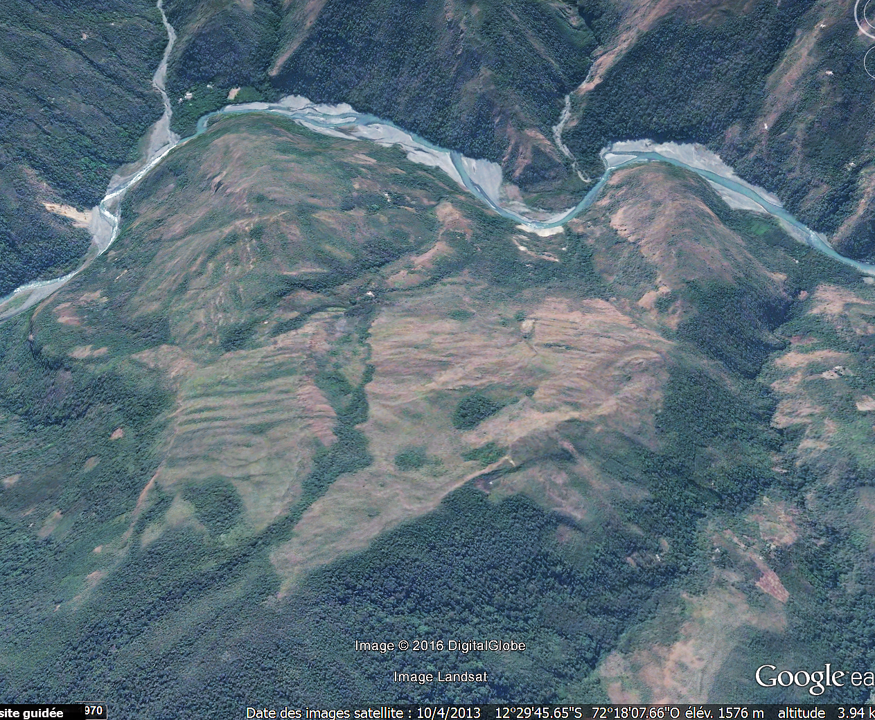
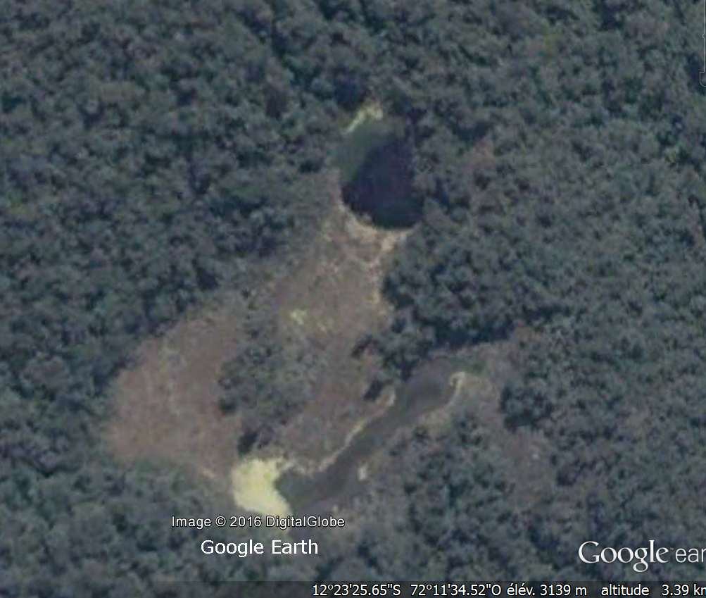
A mountain pan finally attracted my attention: Well exposed, a little steep but a few rugged, irrigated in the middle by a stream, it especially showed traces of an important ancient terraced crops.
The place was located far from any known Inca city, as this important food production seemed to me to be a useful element. I communicated these findings to Thierry Jamin through his profile on a well-known social network, but that no response had never occurred to me then somewhat discouraged me to conduct more research to help him.
Several years passed before I’m interested again about. Meanwhile, my archaeological leisure had led me to other shores, those in the south of France where I live and the many Greco-Roman remains still to discover in. I concluded from this experience that one of the secrets to localize lost sites was follow the ancient paths to find their junction points, and I had drawn the most complete and synthetic map of all we knew about the ancient occupation in Narbonne Gaul: remains, old maps, written accounts, place names, topography…
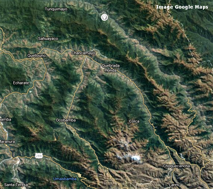
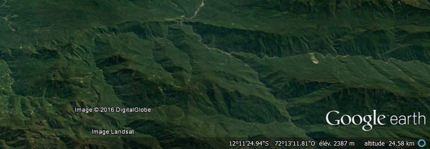
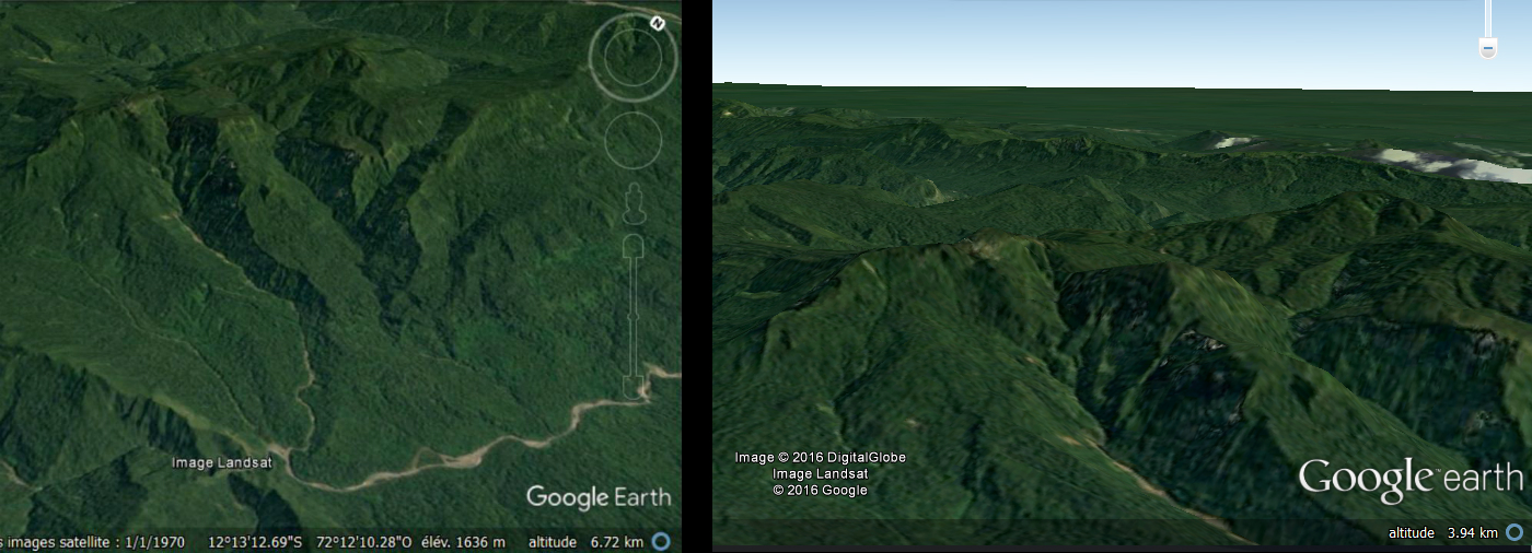
It is in this light that I studied again the Peruvian Andes early 2015. Taking my research where I had left, I then found that all current routes of the region, following the ridges of natural mountain ranges, seemed to converge to Chancamayo and Sahuayaco. From both of this places if you look closely, leaving two passages that allow to go to the next valley. The gap leaving Chancamayo goes directly to the mountain face with traces of ancient crops that had interested me a few years ago.
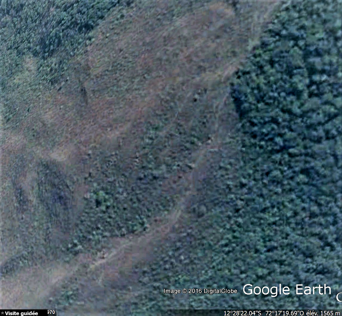
By studying again the site in detail, I found that a path started from the mountain pan, on the opposite side of the valley, towards the forest area.
This path was quite visible on Google Earth, even high enough, which suggested a important attendance. However, no traces of habitations or of any significant settlement for kilometers. In addition, the high gradient exclude whether a roadway. I have concluded that this track could be the remnant of a relatively important Inca path.
I traced this path almost mechanically, losing it here, finding it highest on the ridge he followed, to the north. At this point, it was to me just one of the many Inca paths that roamed the Andes, and that I intended to map.
But something has upset this vision: Following the path direction while it entered the wet zone, I suddenly saw…
A pyramid.
It was totally unexpected, unbelievable.
I spare you the state of excitement which was mine at that time. I changed and changed again the Google Earth angle of view on all axes , but which seems rather be a pond or a tree (the definition of the image is poor, and the building totally lost in the immense mountainous forest) had indeed perfectly four faces erected on three levels and topped by a small dome, all covered with vegetation.
Is this site was listed, known? There was unlikely given the lack of interest and research which had been this high valley, and especially the lost area where had led me the way. An audit is required, however, and I studied eagerly the topic.
I learned from my research that the Incas built a very few number of pyramids, unlike the Maya and Aztecs. The rare Inca buildings of this kind we have found, for example that of Rumicolca just south of Cuzco, seemed to the archaeologists have more held the role of indication signs around large cities, and not worship or burial.
And no trace anywhere of a pyramid discovered north of the valley of Lacco.
From that moment, I knew I had made a fantastic step forward, and I worked days and nights to develop. I had no idea what would result.
I should also mention an anecdote: While, exhausted, I fell asleep in front of the screen, I had a very realistic dream, those that mark us. I was on that road that rose terribly, out of breath. Before me, about fifty meters, the Inca was guiding me, alone, calm, without a word. When I was out of breath, he turned around and waiting. What is strange is that at the time I imagined an Inca covered with gold or something like that, whereas in my dream, he wore a tunic in brown tones and a kind of simple crown. Later, I discover that it was quite like that the Inca was dressed.
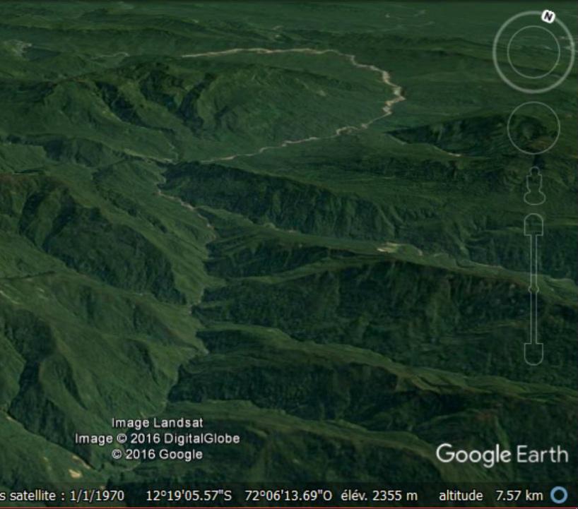
Awake this time and looking more than ever determinate to pursue the draw of the road, I was soon faced its demise in the vegetation, which gradually covered the mountain range. Google Earth zooming out, the track already made became clear to me. It was relatively straight, and went due north, taking a mountain ridge.
Why did the Incas used thus ridges like this then we use the valleys as communication ways? This question struck me, and after some reflection I came to the following conclusion: When we look well the relief of the Andes, we understand that just a few valleys communicate. To use it as ways would mean so constantly climb and descend 4000m high mountains… So pass from a ridge to the other allows being safe from this ordeal. In addition, the wet zone valleys of the Andean are systematically terribly hampered by raging rivers, huge screes, impenetrable vegetation, making them almost impassable.
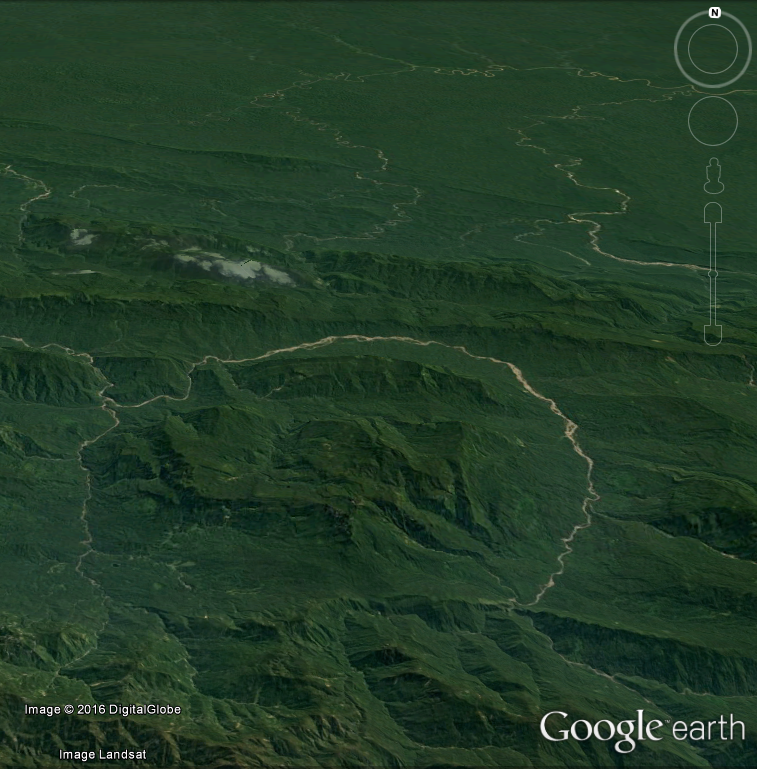
The ridges so as paths. I then traced a hypothetical continuation to my Inca path, following the crest she borrowed northbound. The ridge ends in declining at the edge of the vast Amazon. It died at the foot of a last spur, standing like a wall between the world of the mountain and the forest, east / west perpendicular to my path.
A wall? Not exactly. At the exact spot where my ridge ends, a break in this great natural rampart, unique for kilometers to the east and west, is formed by the course of rivers that meet at this point.
Because it is not one, but three and even five ridges from all directions that come together and decline at that location. A giant funnel, a unique natural junction point in the entire region.
Five ridges, so five many potential paths from all parts of the empire, which end in this point from which the river becomes flat, navigable, and therefore a communication way such as the one the Indians still use to move in the great forest .
The “Amazon door” I thought looking at the hole in the wall, and further, at the green ocean.
And right behind that door… A huge fortification. A natural citadel seemed cut across mythological giants. A final burst of pride of the Andes, coming from nowhere, isolated from the bass surrounding mountain ranges and much more imposing. In fact, a huge rectangular plateau, with vertiginous flanks, surrounded by a moat formed by the rivers that almost completely bypass it.
The gatekeeper of the Andes.
And an ideal spot for a military and commercial site of first importance.
Only assumptions … Because apart from this favorable topographic pattern, often encountered in my Gallo- Roman studies, there was nothing to substantiate my hypothesis, and for good reason : Absolutely everything was covered with lush vegetation.
After having unsuccessfully sought a logic of occupation of the place for hours and put some landmarks of notable points, I had to accept to the obvious: I had arrived at the end of the possibilities for a french internet user installed in his living room.
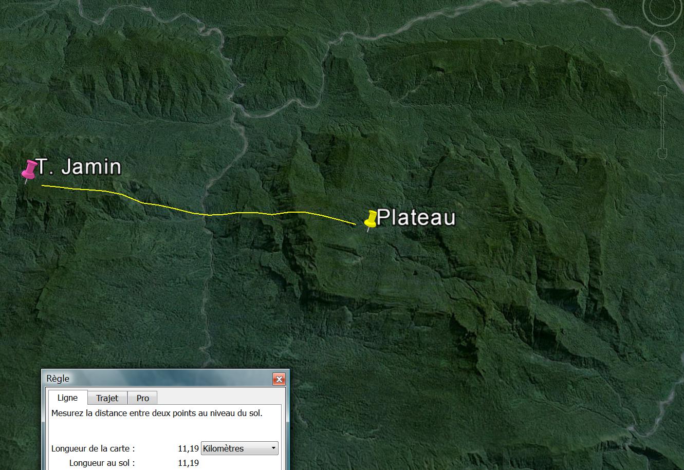
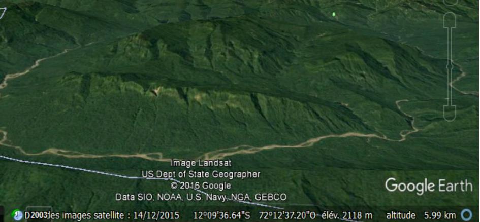
I stepped back on Google Earth to see all of my benchmarks and the work done from my pan of mountain cultivated, after many sleepless nights. And then a landmark, a bit out and of a different color, caught my attention. What had I wanted to signal?
A rocky promontory at the end of a mountain range, vaguely rectangular shape and fairly flat, with three small lakes … all came back to me suddenly. In 2014, Thierry Jamin had published on his Facebook page a picture of the site that would like to explored in 2015. Knowing perfectly the area, I immediately recognized the geographical location and had marked it with a landmark a year ago, while as from time to time I just stood aware of his progress.
How did I not seen it before? How, could it be that Thierry Jamin, I left years before in the Lacco valley beginning near Cuzco , is now a big hundred kilometers further north, on the nearby mountain of my strong keeper of the Andes … what had brought him so far, precisely in this absolutely lost area?
Picture from Google Earth
My enthusiasm started up again. On reading his blog, I learned that he was absolutely convinced that Paititi was on this rocky promontory, because he had managed to decipher the Pusharo petroglyphs, a set of engraved signs that he still considered as major. In the light of the setting sun, like a movie, he managed to discover new symbols, which had transformed his reading of petroglyphs : it was in fact, according to him, a great card for those who went to Paititi, which it clearly indicated the location of this city.
Photo : Thierry Jamin
And this card had led him… at 10km from my strategic plateau.
Local Indians have confirmed to him that significant ruins exist in the area.
While not being a formal proof, the results of his work were a major element that suddenly accredited my hypothesis. Admittedly, we did not have the same opinion about the site: I found his headland too inaccessible and impractical for a commercial city, too small to establish food crops on the scale of a great city … I thought my plateau much better served by rivers, Andean roads through the “door” and the mountain range to the south, larger, more accessible by its rear face, brief more strategic.
Also I found on the plateau five peaks, and one of which is the entire region highest. Again, I tried to put myself in the mind of the Incas: They worshiped the mountains. All we know about them proves their beloved dominant peaks.
Was he right or was it me? Anyway, the area suddenly became incredibly promising, and I felt closer to Paititi. But always I missed THE proof.
I then restarted intensive documentary research on the lost city, in search of a clue. I got somehow translations of ancient texts, from Spanish chroniclers, mostly Jesuit priests, I explored in detail everything related to Paititi the web, from the most fanciful drawings and fantastic stories to academicians negations and even alien duffs debates on forums …
I constituted a kind of file, including text, pictures and interesting hypotheses. I noted as so many other things a description of Paititi made by a chronicler, probably from a witness or a local rumor, stating that Paititi was on a fist-shaped mountain with five peaks, at the end of an isolated canyon in a valley shaped as a volcanic cone. The place would have its own microclimate. The city would have been at the source of a river falling into an abyss, creating a waterfall.
Among the fanciful representations of Paititi, one caught my attention: it seemed older, drawn on parchment. The almost naive trait of the mountain represented in two different ways had heckled me, as well as the small animal drawings listed below, as dancing round in two rows.
Pictures from Exsul Immeritus Blas Valera Populo Suo, Collection Miccinelli
I did not pay more attention on it and, in desperation, turned once again to the careful observation of my plateau. I then exploit a possibility of Google Earth that I had neglected so far : to see from the ground.
I imagined myself as an inca from the mountains discovering for the first time the extent of the Amazon forest, so I placed myself at “the door of the Andes” I had supposed, at the exact location of the opening in the rampart.
It was probably the best idea of all my life.
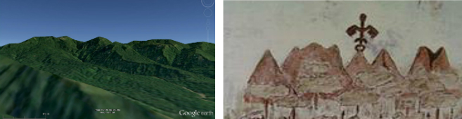
Immediately, the likeness of my plateau from this point of view with the drawing on parchment struck me: five peaks, isolated from any other mountain range… It’s important to understand that in the Andes, which consist of mountain chains, that type configuration in 5 isolated peaks like in the drawing is extremely rare, not to say unique.
Especially, they were located in exactly the same manner as in the first drawing. This one, which was first appeared to me as childish, proved opposite to extremely precise. It noted even by a strange weather vane condor shaped one of the summits, which corresponds exactly to the highest mountain of the plateau, and of the region, which I mentioned a little earlier. Everything is there: the twin mountains, the one with three small peaks, the one which opens in two …
Five peaks … then I thought of the description of a fist-shaped mountain.
Initially I found the plateau seemed viewed from up to a fist, but the Incas did not have this view … The second image explains much better the metaphor used by the witness to describe the mountain to the chronicler: put your right hand in front of the picture and compare with it. Even the veins are in the right direction.
The river also: it bypasses the mountain plateau on the drawing exactly as in reality, its source is exactly well placed, as can be seen on the following views :
In the written description of Paititi, the river was supposed to spring from the top of the mountain and fall into a kind of abyss , forming a waterfall, before rounding the massif.
The river skirting the mountain actually has a tributary that originates directly on the plateau. The image from this angle of view is not very eloquent, but be aware that the top of the source is at 2600m altitude, and that in its first section, the water makes a 700m sharp drop and so… cascades. It then joined the river at an altitude of 1250m as a torrent.
Finally the isolated canyon that arrive to the mountain of Paititi as described…
… mountain that is itself compared to a volcanic cone because of the round shape of the valley that surrounds it :
I understood after some time that the second drawing was actually the representation of the rear view of the plateau, from the hills of the forest. Again, all peaks are well placed, even if in a desire to be understood the author principally returned his previous drawing. Or rather drew the back using the transparency of the paper.
What had seemed to me to be a rope bridge actually represented unambiguously the strong and frank about 2/3 the length mountainous bar on the back of the plateau, which guards the access to the5 peaks via a sort of valley which separates it from this ones.
It’s very strange, in the drawing we can see through, but we can imagine that the representation was made from memory or, more certainly by following oral directions to someone who saw Paititi, and would have described with his words in local language misinterpreted, or described thanks to the form of a fist overcame by a link to image the rock bar, which would have been confusing .
Still, everything fits.
Absolutely everything.
Where are these drawings from? Who made them? Is this a reliable source?
I found with great difficulty the site which I had extracted that representation and get a name: that one of the codex which it is drawn.
The story of this book is amazing. He was found only in 1996 in a dusty library of Naples, by Clara Miccinelli. University of Bologna researcher Laura Laurencich Minelli acquired it and published a study about it. Its author is a chronicler of the time of the conquest, a priest of the Jesuit order named Blas Valera.
The story of this man is very interesting and makes him perfectly credible: son of a Spanish captain and an Indian, he is one of the metis from the first generation; he had the two cultures in him. In other words he is one of the only “Incas” that actually had a written record… He was ordained a priest in 1574 and, like many other chroniclers, he was responsible for the compilation of information relating to pre-Hispanic civilization. Early contact for this purpose with the sages of the Inca nobility in the “Name of Jesus” brotherhood in Cuzco, he would have benefited from information of very first order, much better than those collected by the Spanish chroniclers subjected to the Vice-royalty. Accused of heresy for having taken position too favorably in his writings for the Inca, he will be condemned by the Jesuits themselves and send to Spain.
According to the book, entitled “Exul Immeritus Blas Valera Populo”, his works were stolen on that occasion by the religious order, before being censored of all mentions of the atrocities committed by the Spaniards. They’ll however become essential references relating to Inca history, as his “Historia de occidentalis” according to him watered by Garcilazo de la Vega in his famous “Royal Commentaries” in particular removing a passage describing how Francisco Pizarro assassinated Atahualpa’s generals inviting them to drink poisoned wine…
We also learn in this book that Blas Valera, declared dead in Spain, is actually returned to Peru. The major work on Inca history, the famous “Nueva coronica y buen gobierno” by Guaman Poma, would in fact have been his work (see the detailed history of Blas Valera below). At the same time he wrote the manuscript “Exsul Immeritus” to do justice for himself and to his mother’s people too.
But in my point of view, the real interest of this book is the two views of Paititi. This is THE single work from this period representing this city witch exists.
Like all that has been discovered recently and which calls into question the foundations of the secular works of the domain, this manuscript is still contested by the academy. By proving that these drawings are perfectly accurate, and undoubtedly represent a concrete place, I think that its detractors will have to reconsider their position. Especially since, as we shall see in the confirmation of the discovery, other distinct sources prove in a significant way that it is indeed Paititi that is indicated in these drawings, and therefore Blas Valera had well information of the first order. And was in no way flabbergasted.
Five centuries later, through god only knows where, this is the book-will of this man who brought me a proof beyond all my expectations. This is probably the most credible source for this remote and troubled time.
By digging about the descriptions of Paititi we have received, I also fell, among others, that one of the missionary Francisco Cale (1686), which probably contains the testimony of a local: “the kingdom of Paititi is reached after 5 day by walk from Cuzco. The city Pantiacollo, the central heart of the mythical kingdom of Paititi, is called by the Incas Paiquinquin Qosqo, which means the twin city of Cuzco.”
How is called today the small mountain range at the north end of which is my plateau? ” Cordillera de Pantiacolla”… Particularly evidential, isn’t it?
“My” mountain is situated 120 km north of Cusco, either, through the ridges and highlands of the Cordillera Pantiacolla, about 5 days walk.
I then deepened my knowledge of the Inca history, examined in detail, looking for the slightest geographical indication can still strengthen my discovery. I finally arrived at my purposes :
Vilcabamba, the famous, was founded by Tupac Inca Yupanqui, at the end of a military campaign in Antisuyu. The Inca himself would have passed by Pillcopata, and would have sent one of his generals on Paititi by a parallel road. The campaign was a dismal failure. Vilcabamba was founded at the ultimate point reached by the Inca troops, after a pledge of peace with the Great Ancestor ( yaya ) Lord of Paititi, as to commercially connect this city to the capital Cusco as to monitor it. So Vilcabamba was not far from Paititi , between it and Cusco.
Where it gets interesting is when a century later the Spaniards go to capture the last Inca Tupac Amaru. The Spaniards knew exactly where Vilcabamba, official seat of the resistance, was, because thez sent many emissaries in this place. Chroniclers relate that their troops pass through Choquechanca, crossing a pass, and arrived on ..the Cordillera de Pantiacolla, where they took possession of small fortresses. And then, in no time at Vilcabamba.
So if we summarize: Vilcabamba was founded nearly Paititi linking it to Cusco, and Spanish to reach Vilcabamba went through Choquechanca then Cordillera Pantiacolla.
The Cordillera of Pantiacolla is also mentionned in an ancient Inca legend : Inkarri (the Inca king) had retired after the founding of Cusco in a region bearing that name, in a town named Paititi. I also indicated the Madre de Dios region, where officiated in the seventeenth century Jesuit Father Andrea Lopez, who told his superiors have been in contact with the Inca, lord of Paititi.
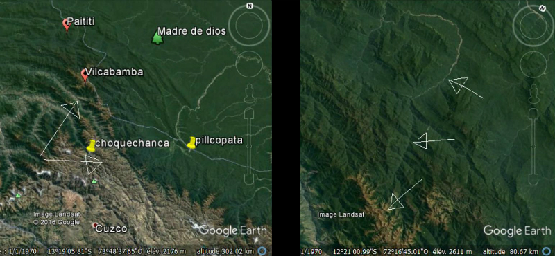
Which would give us in a schematic representation … exactly what we can see on a map if Paititi is on my plateau.
Arrow 1 & 2 > Cordillera of Pantiacolla and cordillera of Paucartambo
Arrow 3 > Paititi’s Plateau
Arrow 4 > isolated canyon previously described
Arrow 5 > North end of the Cordillera Pantiacolla and probable location of Vilcabamba
I can’t say whether the landmark I indicate is or not the real remains of Vilcabamba, burned by Tupac Amaru before his capture, but in a likely location, those traces caught my attention: The black marks are geometric, but also above that point starts a ridge path which goes to right to Paititi, and that has kept the legacy of a large attendance (picture2)
I stopped to blow after days of self-denial. I read and reread everything you just discovered. The legends and testimonies of natives, descriptions of columnists, the historical facts, the ground… These incredible drawings of Paititi… ALL matches perfectly.
Blas Valera … It is thanks to him that I managed to localize Paititi, nearly without a doubt. He realized a full compliance with field drawing. Aside from these animals. It was strange… I wondered how his first drawing could be so precise and fanciful at the same time, with these small animal figures that seemed to dance on the mountainsides.
On the sides … I thought about the geoglyphs of Nasca. And also the beautiful geoglyphs found by Thierry Jamin near the site of Pusharo :
By scrutinizing the plateau from any angle, I seemed to have discerned atypical lines in the vegetation… Could it be that these drawings are not an attempt to language, since the father Valera wrote perfect Spanish and Latin, but a representation of physical patterns on the site?
Moreover, I note that the first formers seemed to be seen in transparency, unlike the others who are “plated” on the mountain pans. The two drawings rows could match with the two sides of the valley that surrounds the plateau… I choose then the first one I identified as “the monkey” or ” the man” and looked if I could see a trace exactly where it should be, according to the drawing.
And again, intuition or incredible luck …
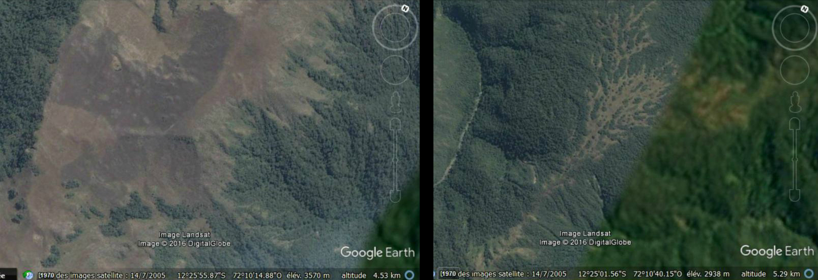
The geoglyph is there.
Exactly the right place. Certain parts are perfectly visible, the head, an arm, which helps me to roughly discover the complete form and to plot it. The rendering is pretty bad on the screenshots below, but by showing / disappearing the plot in Google Earth (2011 version of the software), and playing with the incline of the terrain and « traveling views » in motion, it’s much more obvious.
12°12’40’’ S / 72°08.42’’ O , picture Landsat / Google Earth
Even the esplanade at the level of the navel, which remains free of vegetation, because probably paved, is represented. And also the sex, which I have not traced but can clearly be seeen. I finally held my ultimate proof. A real proof of ground, unique, just as convincing as if I had gone myself on the site. And besides, on the site, we probably would not see it.
By multiplying the angles of view, and with a little work, I got to better define the contours, especially legs which are by far the most difficult part to discern. Here is the result :
To show you even without Google Earth that I did not invent any layout, I invite you to save on your computer the following two images, which are exactly the same size. Go and come from one to the other in any image reader, and you will see what the layouts are from.
And other geoglyphs … One by one, I find them all. In fact 10 of 12, but I ‘m sure that with a better image definition I could find the last two. Some are barely visible, much less than the “monkey”. Streams lines, ground, trees that have grown or not, everything is mixed and it’s difficult, I’m not sure of all, but even with all the bad faith of the world I never could find 10 forms so similar to the drawings in the same order, and so close.
So in the end, 10 huge geoglyphs (the largest, which I called “Condor” measures … 2.5km) patterns on both south and southeast sides valleys of my plateau.
What an awesome site. What a sight it must have of these colossal animal representations from the plateau, and more from the bed of the river, on which we also see clearly drawn crafts. The impression on arriving at Paititi was to be striking… It is really the mystical city of knowledge of the Inca Empire, as legend calls it.
Needless to say that at this stage, for me the question was no longer permitted. I’m used to separate my bit atypical intellectual life and the rest of my social life, but at that moment, the two were deviating dangerously. I had not slept for days. I was in a kind of parallel reality, it was hard to realize.
I was the only human since 500 years knowing where Paititi is.
The Eldorado.
But to return: the days that followed, to clear my head facing all that pressure, I decided to dive back into Google Earth. I went from discovery to discovery.
I replaced pins of remarkable points by tracks, those of possible fields, enclosures or buildings when it was what I had wanted to point, because of the visible rectangles or square shapes in the vegetation, this one having a pushes or color differences remarkable in some place.
I also traced some paths meet, visible here and there on the slopes shave peaks. Despite the average image my eyes gradually accustomed to detect these traces. Better, I mastered increasingly the software, and managed to increase the viewing angles, lightings, movements of “traveling”, which allowed me to discern more traces.
A road, an enclosure, a road, a building, and again, and again… the topography helped me to understand the logic of the city: the Incas were excellent climbers, and indeed the whole site is steep but they could not march vertically, so I found the zigzag of ascendant paths. Similarly, those connect logically buildings and living centers on the plateau, the shorter, especially in avoiding going up and down unnecessarily.
Some buildings are really built on the rock face, but when you know the other Inca sites, nothing surprising. In the end, this is a city that I discover, little by little. I began to discern different neighborhoods, it makes me think … to the drawing.
I realized then that I had taken for simple spots on the design of the mountain were actually representations of the various population centers that I find on the plateau. The major roads that climb the sides of the plateau are also shown in black. Blas Valera realized a real map.
We can see in the field and on the drawing four quarters. The set is especially great. Four districts … as in Cusco, only city able to compete in size with it.
Pantiacollo, the central heart of the mythical kingdom of Paititi, is called by the incas Paiquinquin Qosqo according to Francisco Cale, meaning the twin city of Cuzco.
The second design also details a kind of chamber, an enclosure, which must be the religious center of the city, as the Curicancha (sacred area) was in Cusco. It is placed on the back of the dominant mountain marked by an animal symbol, holding Inti the sun in his mouth. The buildings contained therein are detailed also around
The symbol on the left is a Tocapu representing the Tahuantinsuyu, the Inca Empire, divided into four parts. According to Laura Laurencich Minelli, it translates as “Cuzco and its limits”. The one on the right means: “divided land of the Tahuantinsuyu”, its central part (Cuzco), and the other colored part is the Antisuyu. In accordance with the language of the tocapus presented in Exsul Immeritus, this means that Cuzco was transferred there and that the Tahuantinsuyu had been reduced only to the Antisuyu.
It may be noted that a group of buildings in the heart of the compound seems to be made of gold. If there is a treasure in Paititi it is probably there, in this sacred place. The citadel represented is perhaps the detail of this building, with a clear part at the top (Hanan) and a dark part at the bottom (Hurin), symbols of the politico-religious inca duality. At the top of the drawing, it is written in Latin: “Dominator, here is gold that has not been stolen, here is freedom that has not been torn away, and entrusted to you by the people of Tahuantinsuyu”.
The suspension bridge potentially represents as we saw the rocky bar which keeps access to back of the five mountains. However, for a sake of clarity, maybe that this bar was simply not represented, and that there was indeed a suspended bridge connecting the first and fourth mountains. On both sides seem to be represented two caves. According to the researcher Laura Laurencich Minelli, a great specialist of the manuscript from which this representation is drawn, these caverns would be two hells reserved for christians and indigenous people respectively. This last hell bears the name Supayhuachi, synonymous with Upaymarca (the dark world of shadows); A Jesuit letter of 1614 indicates that to enter the Upaymarca, the souls had to cross a bridge of woven hair that could be that of the illustration.
A small drawn hand pointing to a form in which it is written in capacquipu (another form of Inca script) a verse from the Apocalypse (6, 9-10) which refers to the destruction of the indigenous world and witch calls to the justice. To summarize, this drawing informs us that the Paytiti is the new center of what remains of the Inca Empire, which receives the Tahuantinsuyu gold to preserv it from the Spaniards, but is also an hell (for the traitors) in two versions : for christian and indigenous.
It is difficult to distinguish precisely these elements on the face of the mountains covered with vegetation. Would the enclosure be underground? This would go in the direction of Paititi’s descriptions, witch insist about the many tunnels and caverns on the mountain, but also testimonies of Indians who report to the Jesuits see “the guardians of the Paititi sanctuary called Paco-Pacuris, dressed in white robes coming out of Caves in the mountains “. Today, in the precise area where I discovered Paititi, there would still exists an unknown Indian tribe named … the Paco-Pacuris.
The representations taken from the manuscript “Exsul Immeritus Blas Valera Populo Suo” written by Blas Valera leave no doubt about the identity of this city. Indeed, in spite of the circumstances in which he realized this work, the name of Paititi appears in an encrypted form on this drawing: it is written in tocapus, the lost writing of the Incas, which proves once again the concordance between the “city of knowledge “of the legend and the reality of Paititi. Blas Valera gives in his works the keys to decipher this writing, and the researcher Laura Laurencich Minelli translated the symbols present on the drawing as designating precisely Paititi:
For those who want to know more about Blas Valera, the fascinating story of his life and the cause he defended against and against everything, here is a summary from the work of Laura Leurencich Minelli, which leaves no doubt about his credibility:
Blas Valera is the son of a Spanish captain and an Indian, he is one of the first-generation Métis: he carried both cultures in him. He was ordained as a priest in 1574 and was, like many other chroniclers, responsible for the compilation of information relating to pre-Hispanic civilization. As early as 1575, we find him in the fraternity Number of Jesus in Cusco, a place of meeting and discussion between the Spanish priests and the Inca nobility. It is probably in this environment, and encouraged by his superiors Father Muzio Vitelleschi and Father Mariana, that he is beginning to adopt a rather critical view of the terrible abuses of the Spanish viceroyalty and the unconditional support the church brings her in the person of Father Acosta.
Blas Valera will firmly oppose him: « There are no legal titles or noble causes that justify the conquest and occupation of this part of the world or the exploitation of the Tahuantinsuyu people (…) A man of good will can not say that Our Lord has decided to withdraw these lands from the pagans and grant them to Spain as a result of the many merits acquired by the Catholic Monarchs, using the excuse of the unfathomable will of God who Has placed in their hands authority over all kingdoms. » The conquerors, « instead of poisoning, shooting, crushing, stealing and melting their gold » should have been « looking at around with pure eyes (…) the consciousness of the creature that recognizes the breadth of the eternal Father. » To summarize, « the salvation of the people is the supreme law », you can not use « wrong the name Ineffable of God, and call upon him to commit crimes. » Blas Valera was condemned for heresy and sent to Spain in 1583.
His works will be stolen on this occasion, before being censored of all their references to the atrocities committed by the Spaniards. Nevertheless, they became indispensable references to Inca history, such as his “Historia de Occidentalis”, witch according to him was watered down by Garcilazo de la Vega in his “Royal Commentaries”, notably by removing a passage describing how Francisco Pizzaro had murdered the generals of Atahualpa inviting them to drink wine poisoned by the Dominican Johannes Yepes, an episode that had deeply revolted Blas Valera and other Jesuits, and remained secret.
It must be understood that Viceroy Toledo, “the persecutor of the naives and detractor of the Society of Jesus for the protection it gave to the innocent Indians,” according to Valera, had the unfortunate tendency to destroy by fire any compromising document or information that could have reached Europe, where, even in the period of slavery, many voices rose to denounce the Spanish barbarism in South America. Blas Valera was the victim of this censorship, like Father Anello Oliva, Jeronimo de Montesinos … The letter of Francisco de Chaves seeking to inform the king of the poisoning of the generals of Atahualpa by Pizarro was destroyed, like any other traces of Inca written culture such as quipus, topacus, Jesuit manuscripts describing the advanced civilization, traditions, and the true ancestral history of this people, etc. Only were tolerated the chronicles witch valued the victors and passed under silence the eager destruction of the great Inca civilization. And of its people : more than 95% of the population was exterminated by deseases and unhuman work on the mines.
During his exile in Spain, Blas Valera was tried and dismissed. Thanks to his supporters of the Jesuit order, he has doubtless escaped the real execution, but was proclaimed dead officially. In response to this civil death, he chooses to “live and fight for the fatherland”. It is in the utmost secrecy that he manages to embark for Peru in 1599, thanks to the help of Father Mariana and Father Muzio Vitelleschi. Officially dead, it takes the name of Ruruiruna, and hides once arrived. In 1603, in his Breve Relation, Torres Bollo proposed the creation of a republic and an Indian church under the direction of the Jesuit fathers, named this project “Le Paytiti”. He would have been, with Blas Valera, the origin of this project.
Blas Valera writes “El primer Nueva Coronica y buen Gobierno” witch concerns the history of Peru from the pre-Incas period to the civil war of the Spaniards. But the work, which is more than 1200 pages long, describes the life of the natives under Spanish rule, and therefore the abuse of exploitation by taxes or personal service, despite the royal ordinances. Finally he proposes a program of reform to put an end to this unbearable situation for the new native subjects of his Majesty, whom we call Paytiti. Indeed, this name was too dangerous in the context of the unrestrained search of this city by the viceroyalty of Peru. To refer to this name directly would have mean the end of this kingdom of the surviving Inca, still preserved, and therefore of all the Jesuit project.
At the origin of this project, the extermination of an ethnic group by deception and under the guise of evangelization (Babel for Valera). The Machiavellian destruction of the Inca Empire caused a disequilibrium “Pachacuti” dangerous for native cosmology, between its Hanan and Hurin. As a solution, the project proposes a new balance, a new duality, this time between Europe and the world of the Andes, in the light of Jesus Christ. The utopian reform contained in the Nueva Coronica proposes the political personality of an Inca blood prince to govern Peru, seconded by four employees at the head of a world divided into four parts. This government would be under the authority of Don Philip (King Felipe III), with whom a second Inca leader would be permanently present to advise him. The administrative system would be pyramidal as in the time of the Incas, from the blood princes leading a million men (huno aucacamayo) to pichca Pachac at the head of 500 men. A fundamental part of the reform is to give back to the Indians their legitimate properties, lands that were sold in His Majesty’s name, and a distribution of labor according to the traditional work cycles of the inca Mitae. The whole would be governed by an amalgamation of the old system with the new colonial institutions.
Nueva Coronica also contains a hidden message, inserted in the 400 illustrations that punctuate the book, through the use of tocapus, these Inca symbols that can be qualified as a writing as they allow to pass a message. They describe another duality in governance, this time only addressed to the Inca rulers: this message explains the cosmic dualism between heaven and earth, between the solar calendar that is hanan and the lunar one that is Hurin. It is the wisdom and experience of Inca governance that is transmitted here to future generations of Inca leaders, concerning both the balance to be preserved in their own local governance and the balance to be maintained within the framework of dual government with the King of Spain. It is understood that this message, which will speak to the Incas, is not expressed in a comprehensible way to Europeans, for it is based on cosmology and indigenous beliefs, and therefore would immediately be considered heretical. It seems likely that the Inca nobility itself contributed to the development of Nueva Coronica in partnership with the Jesuits, which explains the possible double reading of the project and the variations as much on the substance as on the writing.
It was Brother Gonzalo Ruiz who produced all the illustrations. This faithful acolyte of Blas Valera proposes to Guaman Poma in 1611 to “lend” his identity to the officially deceased Jesuit so that the major work which he was writing has a chance of being diffused. Poma agrees against “a cart and a horse,” but, realizing what is going on, he soon makes Ruiz sing. In 1615 Gonzalo Ruiz and other Jesuits involved in the secret project (H. Cumis, J. Montesinos, etc …) make him sign a contract that binds him to them and at the same time forbids him to betray them. Blas Valera even goes so far as to write in a false Castilian to mask his authorship in this work.
In 1615, Fr. Muzio Vitelleschi, who secretly supported Blas, valued from the beginning, acceded to the seat of Father General of the Society of the Jesuits. The Father General who had to give the king and then publish and massively broadcast the Nueva Coronica, is in a difficult situation. The project, if it is perfectly in accord with the faith, is totaly in contradiction with the interests of the Spanish crown in the West Indies. The publication of the book would open a debate which could lead to the outright exclusion of the Jesuit order of the subcontinent of the Americas, accused of plotting against the Spanish with the Indians. If it is assumed, following our discovery of Paititi, that not only did the Father General authorize the theoretical project, but that its practical realization within the Spanish lands was a possible secret reality for which he assumed responsibility, consequences could have been much worse for the Jesuits. This mestizo project was closely related to the heresy, and the Pope, pressed by the colossal power of Spain at the time, might have been contrived to excommunicate the whole Order …
The position of the Order for the defense of the Indians converted in Peru already rendered the situation tense with Spain, and the latter’s envoys to Rome sought everywhere evidence which would enable tham to compromise the Order. So that in 1617 Father General “purifies by fire” the archives of the ARSI in Rome, destroying in particular any trace of the mission entrusted to Blas Valera. Only a few documents in Italian referring to it will escape the purge.
The mission of Blas Valera was not yet finished, and, always in the greatest secrecy, he completes the writing of another work, both intended to give the key (topacus) of the double reading of Nueva Coronica which he claims to be paternal, to indicate the secret place of which the noble Inca confided to him the existence where this project would be realizable, and to express much more clearly his personal opinion about the events of the conquest of Peru. Deceit of Cajamarca and cowardly poisoning of the Inca generals, attitude of Viceroy Toledo, guilty passivity of Father Acosta … this work is a real shiver. Signed this time by the hand of Blas Valera, it is destined to remain secret, and is only intended for Father General Muzio Vitelleschi: it is his “Exsul Immeritus Blas Valera Populo Suo”, in which we also find drawings Of Paititi.
Conclusion
I consider that by my work I gathered enough elements on July 20, 2015 to affirm that most of the vestiges of the great capital city of the kingdom of Paititi, originally called Pantiacollo originally and took the name of Paiquinquin Qosqo for the Incas, known today as Païtiti, is distributed within a radius of 10km around the main summit located at 12 ° 10’34 ” S / 72 ° 12’53”W.
It is very probable that it was this great “twin city of Cusco”, and not the small city of Vilcabamba, which served as a refuge and a real capital for the last Incas and their court, which retreated into the region between 1534 and 1572. Vilccabamba would have served only as a physical and diplomatic interface, in order to hide from the Spaniards the existence of the real capital, Paititi, the mystical city possibly at the origin of this people, shelter all sacred objects and Inca knowledge. This would explain why Tupac Amaru, fervent defender of the beliefs and the Inca cause, burned Vilcabamba before surrender without a fight. It would have put an end to the tracking of the Spaniards, who would sooner or later find Paititi and his refugee people if they had continued to seek him. By setting fire to the little Vilcabamba who lost all strategic role after the resistance ended, he would have incited the Spaniards to abandon this inhospitable region quickly, which they did. Paititi, the secret city of the Incas, never having been discovered by the Spanish troops, it is possible that the Inca dynasty survived there after 1572. Numerous testimonies confirm this hypothesis. (See the work of Marco Polia on the writings of Andrea Lopez).
Since that day, I am trying to reinforce the evidence that I have, because I am well aware that nobody will believe me, and that some will try to discredit me to better take ownership of this discovery the day they will set foot on this plateau.
I would like to dedicate this discovery to my late grandfather Jean Pélissier who gave me a taste for archeology ,and to my parents.
Vincent Pélissier 2016
Confirmation of the discovery
I made this discovery a little quick, I am aware of it, and even if I consider that the evidences provided is already largely solid enough to make my discovery of Paititi stand out from an umpteenth few credible theory on this subject, I have endeavored to further strengthen this discovery, by studying the works of the greatest specialists in Andean archeology and anthropology, the accounts of the chroniclers of the time, and also the archaeological remains of the land, in the light of my discovery. I have made a lot of progress in my knowledge of the sources. As you will see, it has been quite successful.
By converging Google Earth views, Blas Valera’s drawing, and legends describing the city, I came across the most striking and convincing evidence first, by chance. I suppose if it had not been the case, it was by gradually bringing together the following elements that I would have finally found the city.
PS: Thank you for excusing the spelling mistakes and grammar errors in English
© Vincent Pélissier 2016